Aviation - Hazards - Convection and Thunderstorms

Convection and Thunderstorms
Deep convection in the form of Cumulus congestus clouds (also referred to as towering Cumulus or TCU) and Cumulonimbus (CB) clouds can lead to the development of thunderstorms, squalls and in extreme cases funnel clouds (water spouts or tornadoes). Individually and collectively they pose a major hazard to aviation operations on the ground and in the air due to the likelihood of:
- severe turbulence,
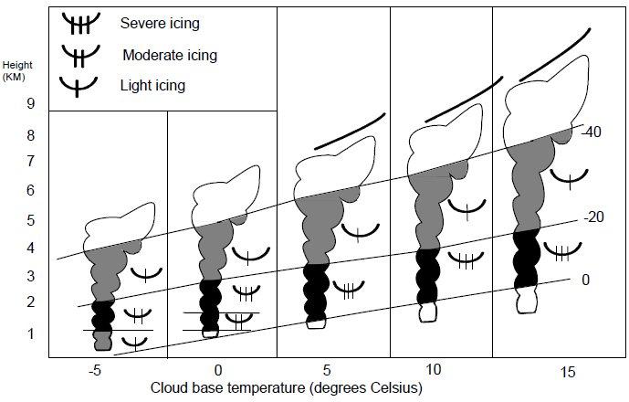
- severe icing,
- microbursts, generating squalls or gust fronts giving severe low-level turbulence,
- lightning,
- high liquid water content, e.g. rain water content, and/or
- hail.

Whilst individual CB clouds may have a lifetime of 1½ hours, the most intense CB development and thunderstorm/lightning activity is associated with multi-cell, mesoscale convective systems which may develop further into 'supercells'. Such systems are long-lived due to the spawning of daughter cells and may last for many hours. Forecasters (and aviators) must always be aware of the various typical synoptic scenarios that are likely to generate thunderstorm activity.
Lightning can occur in and near CB clouds, including the anvil layers and the sub-anvil atmosphere. Lightning can release an electrical discharge of some 20 coulombs and a potential difference of some 108 or 109 volts. Electrical discharges may occur within the cloud, referred to as intra-cloud lightning, and between cloud and ground, referred to as cloud-to-ground lightning. Generally, intra-cloud lightning is weaker than cloud-to-ground lightning.
Thunder is the audible manifestation of the electrical discharge, caused by the violent heating and expansion of the atmosphere surrounding the path of the lightning strike.
The effects of lightning on an aircraft (and its crew and passengers) are many.
If lightning strikes a previously sound, metal bonded structure, the aircraft will remain structurally sound, and the passengers and crew will not be directly affected by the strike’s voltage and current, due to the Faraday Cage effect. However, entrance and exit burn marks will be evident on the skin of the aircraft. This results from the temperature of 30000-32000 K within the lightning channel. If the discharge is adjacent to or through structures such as aerials, then these structures may be destroyed. The effect of a lightning strike on both passengers and crew will induce shock, and possibly fear. At night a lightning strike may cause the crew to suffer temporary blindness, or degraded vision.
Lightning strikes on modern composite materials will cause delamination of the material. If such strikes are upon structurally important areas of the aircraft, its integrity may be compromised. For this reason, lightning strikes on composite helicopter blades are particularly hazardous.
Following a lightning strike, electrical/electronic systems may fail, with circuit breakers tripping. Magnetic compasses will become untrustworthy.
Radio communications and navigation equipment may be adversely affected. The Automatic Direction Finder (ADF) will often point into the storm’s centre.
Small hail (METAR code GS) is hail or graupel of less than 5 mm in diameter. True hail (METAR code GR) is hail of 5 mm or more in diameter. GS and GR may fall from CB clouds. GS (not GR) may fall from Cumulus congestus (TCU or Towering Cumulus cloud). The phenomena should not be confused with Ice Pellets (METAR code PL) that originates from stratiform cloud.
Hail is formed in the updraughts of convective (TCU or CB) cloud. The stronger the updraught, and the greater the cloud vertical extent, the larger the hailstone that can be sustained.
Hail of small size will have little effect on the structure of an aircraft, merely bouncing off the airframe. However, even small hailstones have a marked detrimental effect on visibility. The onset can be rapid, surprising the pilot.
Hailstones can attain sufficient size to cause damage to the skin of aircraft, which may affect the aircraft’s aerodynamics, and possibly shatter windscreens.
Hail may severely damage propeller blades and engine blades. Hail may block air inlets or may be deposited somewhere within air intakes.
Sudden hail showers may leave an extremely slippery surface on runways and taxiways. So, even if the shower has passed and the visibility and cloud may be described as fit for attempting a landing, breaking action may be adversely affected.

Squalls can often accompany heavy showers or thunderstorms. They are characterized by an abrupt and large increase of wind speed with a duration of the order of minutes which diminishes rather suddenly.
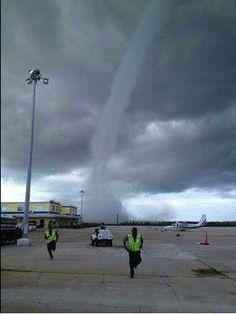
Funnel clouds, manifesting as water spouts (over water) or tornadoes (over land), can develop in extreme cases. They are caused by the reduction of pressure at the centre of the vortex. A tornado is a violently rotating storm of small diameter that is produced in a very severe thunderstorm. The funnel cloud extends from the base of a CB to the ground. A water spout occurs over water and its behaviour is characterized by a tendency to dissipate upon reaching shore.
CLICK HERE to return to our homepage
