GSICS
Structure
In accordance with the GSICS Implementation Plan, GSICS relies on a GSICS Coordination Centre (GCC), several GSICS Processing and Research Centres (GPRC) operated by each satellite operator, and Calibration Support Segments (CSS) such as field sites and laboratories. Activities are overseen by a GSICS Executive Panel assisted by a Research Working Group (GRWG) and a Data management Working Group (GDWG).
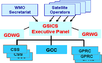
The Executive Panel, consisting of representatives of the participating agencies, sets strategic priorities and monitors and evaluates GSICS evolution and operations.
The GRWG and GDWG advise the Executive Panel and assist in the planning and implementation of GSICS research and data management activities respectively. The GRWG consists of scientists, and the GDWG of data management experts, representing the participating agencies.
The GCC, located at the NOAA National Environmental Satellite Data and Information Service (NESDIS) facility in Camp Springs, Maryland, U.S., supports technical coordination among GPRC and CSS entities and is monitoring GSICS progress and milestones. It also maintains an important Internet hub of information and data exchange between GSICS members and data users and is responsible for publishing the GSICS Quarterly newsletter.
The GPRCs, one at each operational satellite agency, are responsible for pre-launch calibration, inter-calibration of their own agency’s sensors with other satellite sensors, and supporting research activities.
The CSSs are participating satellite agencies, national standards laboratories, major NWP centers, national research laboratories, and university collaborators. CSS activities include:
- Providing in-situ observations of Earth reference targets (e.g., stable desert and perpetual snow areas), long-term specially equipped ground sites, and special aircraft and field campaigns
- Observing stable extra-terrestrial calibration sources, such as the Sun, Moon, and stars
- Comparing radiances computed from NWP analyses of atmospheric conditions with those observed by satellite instruments
- Championing and supporting benchmark missions of the highest accuracy to serve as calibration standards in space
- Developing calibration “best-practices” procedures
- Supporting efforts to make satellite instruments SI-traceable.