Aircraft-Based Observations Benefits
| Benefits & Impact | 
|
Key Papers & Reports
- WIGOS Technical Report 2021-1, The Benefits of Aircraft-based Observations and AMDAR to Meteorology and Aviation - Update to WIGOS TR 2014-1
- GSL Seminar: Commercial-Aircraft-Based Weather Observations For NWP: Data Coverage, Forecast Impacts, And COVID-19, E. James et al, NOAA. Seminar link ¦ Presentation ¦ Audiovisual Presentation
- WIGOS Technical Report 2015-1, Impact and Benefits of AMDAR Temperature, Wind and Moisture Observations in Operational Weather Forecasting
- WIGOS Technical Report 2016-01, AMDAR Benefits to the Air Transport Industry 2016-01, Version 1, Oct 2016
- WIOGS, Technical Report, 2018-01, October 2018, Benefits to the Environment and Society from the Availability and Use of AMDAR Data
For additional information and materials on the benefits and impact of AMDAR data see the AMDAR/Resources/Programme Development area.
Benefits and Impact of ABO and AMDAR Data
Like many of the modern public or government-initiated success stories, the development of the Aircraft Meteorological Data Relay (AMDAR) observing system has relied and thrived on what has come to be known as Public Private Partnerships (PPP) between governmental meteorological and hydrological services (NMHS) and their airline partners.
For these partnerships to happen and to work, there has to be a demonstrable benefit to both parties and, given the government involvement, a benefit also to society and the public.
The great benefit of AMDAR data in particular to meteorology, is the fact that the data are derived according to specific meteorological requirements, so that the meteorological parameters measured are reported at a high frequency during the take off and landings of participating aircraft. What this means is that the aircraft provides a "meteorological snapshot" of the atmosphere on a vertical trajectory, in a very similar way to which balloons bearing meteorological radiosondes do. This generation of vertical profiles by AMDAR aircraft certainly makes the programme useful; but there are three elements of the AMDAR observing system which make it especially valuable:
- AMDAR wind and temperature data have been shown to be similar in data quality (i.e. accuracy or uncertainty of measurement) to that of radiosondes;
- The measurement sensors and systems on the aircraft are able to produce this accurate data at a very high rate or frequency of measurement, thus providing very fine detail within the vertical profiles; and
- Owing to the frequency at which aircraft are landing and taking off from airports, these vertical profiles can be produced on at least a 3-hourly basis at many airport locations.
It is these features of the AMDAR observing system that have led forecasting meteorologists to provide testimony that these data are very valuable and useful and provide significant improvement to applications for monitoring and prediction of weather systems and phenomena such as:
- Surface and upper air forecasts of wind and temperature;
- Thunderstorm genesis, location and severity;
- Wind shear location and intensity;
- Low cloud formation, location and duration;
- Fog formation, location and duration;
- Turbulence location and intensity;
- Jetstream location and intensity;
- Precipitation amounts and rates; and,
- Conditions leading to aircraft icing.
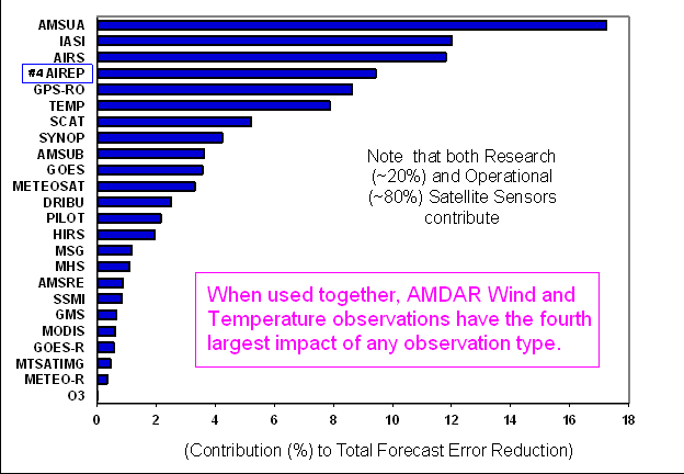
As has been highlighted in a previous WMO AMDAR Observing System Newsletter article in Volume 4, Summary of Recent Studies on the Impact of AMDAR data in NWP Forecasts (Petersen), meteorologists are able to use modern numerical weather prediction (NWP) systems to precisely quantify the benefits of aircraft-based observations and have determined that these observations are second only to high-volume satellite data in impact on NWP systems (See figure at right - Impact of various different data sets on accuracy of 24-hour ECMWF forecasts, based on Radnoti et al, 2010 - click to enlarge). Quantitatively, AMDAR and other aircraft-based observations generally provide an improvement in forecasting ability through a reduction in NWP forecast error of up to 15-20%.