Global surface temperature data sets
The global surface temperature assessment is based on the instrumental records of the air temperature measured at 1.25 to 2 metres above the surface level on the land. Sea surface temperature measurements are recorded by various observation platforms, including ships and buoys. The annual assessment is based on these measurements after they have been quality controlled to filter data errors and homogenized.
The development of climate datasets is based on the following:
- Routinely disseminated daily and monthly weather and climate observations by the National Meteorological and Hydrological Services of the 189 WMO Members following the WMO standards for data collection, quality control and exchange;
- Historical climate records dating back to 1850, including those available from marine climate summaries;
- Recovered old climate records worldwide as part of continuous data rescue efforts promoted by WMO and its Members;
- Peer reviewed scientific methods for quality control, homogenization and interpolation to constitute high quality global climate datasets.
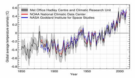
There are three centres that maintain global climate datasets and calculate global average temperature and related anomalies at monthly and annual timescales:
- Met Office, UK, in collaboration with the Climatic Research Unit at the University of East Anglia (United Kingdom);
- National Climatic Data Center, which is part of NOAA (United States);
- Goddard Institute for Space Studies, which is part of NASA (United States).
The individual datasets and further background material on the data can be obtained at the respective institution web pages:
Other data sets:
The Comprehensive Historical Upper-Air Network (CHUAN) by ETH Zurich
|