WMO El Nino/La Nina Update
WMO El Niño/La Niña Update
27 May 2019
Download pdf versions: English Français Español
Current Situation and Outlook
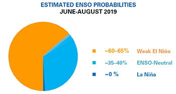
Sea surface temperatures in the tropical Pacific have generally been at borderline to weak El Niño levels since October 2018. However, it was not until February that some atmospheric indicators reacted to these warmer than average sea surface temperatures. WMO Global Producing Centers of Long Range Forecasts predict ocean temperatures to remain close to current levels through the June-August period, but may ease in September-November. Given current conditions and model outlooks, the chance of El Niño during June-August 2019 is estimated at 60-65%, decreasing to 50% from September 2019 onwards. The chance for a strong El Niño during 2019 appears low. National Meteorological and Hydrological Services will continue to closely monitor changes in the state of ENSO over the coming months.
From October to December 2018, sea surface temperatures across the east-central tropical Pacific were at borderline to weak El Niño levels, but the atmosphere did not respond to the warmed sea surface temperatures, indicating little coupling between the ocean and atmosphere. In January 2019, the sea surface temperatures temporarily dropped to a level near or just below the El Niño threshold, and in February the atmosphere finally began to show some El Niño-like patterns, including weakened trade winds in parts of the tropical Pacific and above-average cloudiness and rainfall near the International Date Line. These more El Niño-like atmospheric patterns helped enable the past-central tropical sea surface temperatures to rise again during February 2019, and the continuation of ocean-atmospheric coupling, although weak, has supported the maintenance of weak El Niño-level sea surface temperatures to the present time.
The temperature of waters below the surface of the tropical Pacific, from the west-central Pacific eastward and extending to several to hundred meters below the surface, was above average during much of 2018 and early 2019. However, from April onwards into May the temperature of these waters at depth has cooled considerably. This deeper water often precedes the conditions at the ocean surface. Thus, the currently observed weak El Niño-level sea surface temperatures are likely to continue in the short-term, but if the waters below the surface continue to cool, the El Niño may weaken to borderline or neutral levels in the coming several months. However, if the trade winds weaken again, as they have done periodically over the last four months, an increase in the temperature of the waters below the surface could enable current ocean surface conditions to continue well into the second half of 2019.
About two-thirds of the models from the WMO Global Producing Centers of Long Range Forecasts predict ocean temperature patterns to continue at borderline or weak El Niño levels through the June-August period, and over half of them predict continuation through September-November. Model predictions of the strength of the El Niño, as characterized by the departures from normal of sea surface temperatures in the east-central tropical Pacific, range from approximately 0.5 to 0.9 degrees Celsius above average during June-August. Based on the model predictions and expert assessment, the probability of El Niño conditions being maintained is estimated to be about 60-65% through at least June-August, and about 50% for September-November 2019. However, outlooks made at this time of the year are uncertain beyond July or August and should be considered with caution. Even if ocean conditions do remain at El Niño levels for the next several months, the chance for a strong event (sea surface temperatures in the east-central tropical Pacific rising to at least 1.5 degrees Celsius above average) during this period is low.
It is important to note that El Niño and La Niña are not the only factors that drive global climate patterns, and that the strength of El Niño/Southern Oscillation (ENSO) does not automatically correspond to the strength of its effects. At the regional level, seasonal outlooks need to assess the relative effects of both the ENSO state and other locally relevant climate drivers. For example, sea surface temperatures over the Indian Ocean, the southeastern Pacific Ocean and the Tropical Atlantic Ocean are also known to influence the climate in the adjacent land areas. Regionally and locally applicable information is available via regional and national seasonal climate outlooks, such as those produced by WMO Regional Climate Centres (RCCs), Regional Climate Outlook Forums (RCOFs) and National Meteorological and Hydrological Services (NMHSs).
In summary:
- Sea surface temperature patterns in the tropical Pacific Ocean were at borderline to weak El Niño levels in April and early May 2019. Some El Niño-like atmospheric patterns have also been present.
- Model predictions and expert opinion indicate a 60-65% chance that El Nino will be present during June-August 2019.
- Chances for El Niño continuing into the following season of September-November fall to near 50%. However, long-lead outlooks made at this time of year are particularly more uncertain beyond August.
- Sea surface temperatures are most likely to be about 0.5 to 0.9 degrees Celsius above average in the east-central topical Pacific during the June-August 2019 season. A strong El Niño event during 2019 appears unlikely.
- Through the September-November season of 2019, the development of La Niña is extremely unlikely.
The state of ENSO will continue to be carefully monitored. More detailed interpretations of regional climate variability will be generated routinely by the climate forecasting community over the coming months and will be made available through National Meteorological and Hydrological Services.
For web links of the National Meteorological Hydrological Services, please visit:
https://public.wmo.int/en/about-us/members
For information and web links to WMO Regional Climate Centres please visit:
http://www.wmo.int/pages/prog/wcp/wcasp/RCCs.html
For information and web links to Regional Climate Outlook Forums (RCOFs) please visit:
https://public.wmo.int/en/our-mandate/climate/regional-climate-outlook-products
For the latest global seasonal forecast based on WMO Global Producing Centres of Long Range Forecasts, please visit:
http://www.wmo.int/pages/prog/wcp/wcasp/LC-LRFMME/index.php
An archive of all WMO El Niño/La Niña Updates issued so far, including this one, is available at:
/wmo-el-ninola-nina-updates-archive
