WMO ABO Newsletter - Volume 22, November 2021
Welcome to the October 2021 AMDAR NewsletterOn behalf of the WMO Joint Expert Team on Aircraft Based Observing Systems (JET-ABO), Chair Curtis Marshall, Vice-Chair Nicolas Rivaben and I welcome you to the October edition of the WMO AMDAR Observing System Newsletter. First and foremost, we hope that this Newsletter finds you and your families all in good health during these trying times of COVID-19. After six months from the previous newsletter, I did not expect to be writing my introductory notes still under the effects of this global pandemic! The aviation industry and our ABO participating airlines still are struggling to operate as best they can with reduced operations, staff resourcing issues and, in some cases, national and international travel restrictions implemented by governments around the world. However, we have seen some increases to our global network of ABO data and it is hoped that, along with the short/medium haul tourist sector, we will start to see business travel pick back up again. The sustained increases obviously will depend on how COVID is managed! So, to this edition…although COVID has impacted on some of our planned development work within the ABO communities, we still have some interesting articles for you. In addition to the WMO updates on ABO activities – turbulence (both EDR and DEVG), water vapour measurement (WVM), Regional Program updates and WICAP – we will hear from authors regarding the status of the UAS Demonstration Campaign (UAS-DC), an update on Aircraft Derived Data (ADD), the availability of Third-Party Data (TPD) as well as a report on the quality of TAMDAR data. Despite the global situation, we take this opportunity to thank the authors for their time and contributions and hope that you, the readers, enjoy the content of this edition and welcome feedback on the articles and any other ABO matters. Please feel free to contact the authors and the Newsletter co-ordinators using the contact details provided. Stay safe and well… stewart [dot] taylor |
Status of Aircraft-Based ObservationsThe graphic below shows the smoothed monthly average of daily aircraft-based observations (single point measurements in space and time, mainly of air temperature and wind speed and direction, made by an aircraft) transmitted on the World Meteorological Organization (WMO) Global Telecommunications System (GTS) since 2007 up to October 2021, as contributed by:
The observations from the WMO AMDAR observing system are the output from 12 operational AMDAR national and regional programmes in cooperation with some 43 national and international participating airlines, as listed on the WMO website. 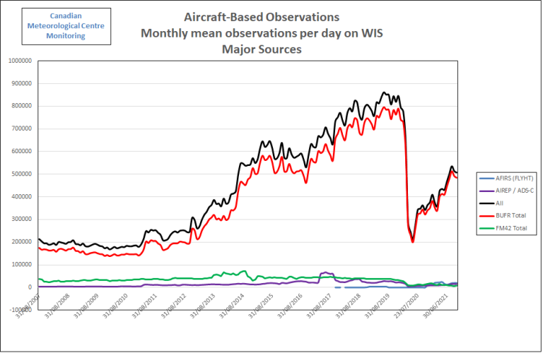
ABO Data Volumes, Coverage and Impact of COVID-19The graph shows that recently towards the end of 2019 and start of 2020, aircraft-based observations data volumes had increased to a historical maximum of more than 850K observations per day on the GTS, with AMDAR observations making up the majority of these at around 750K observations per day. From March 2020, as a direct result of the impact of COVID-19 on the aviation industry and airlines, the volume of aircraft-based observations overall fell to around 245K observations per day and to 230K for AMDAR - around 30% of December data volumes for both. The biggest monthly reduction occurred in May 2020, with only an average of 210K observations per day available. Since then, data levels have gradually increased overall with mean daily total observations at around 507K observations per day in October 2021, which is around 60% of the December 2020 data volume. |
The graphic below shows ABO data volumes by WMO region since January 2018, where it can be seen that the recovery varies greatly from region to region and on a monthly basis within each region, as countries and regions emerge from the crisis and aviation operations start to increase accordingly. Over the past several months, data levels have steadily climbed over the USA, while in other WMO regions, the recovery has stalled or even deteriorated. While the aviation industry outlook still remains relatively uncertain, we can expect that the recovery will continue slowly, based on the forecasts from IATA that:
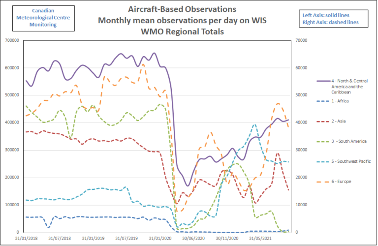
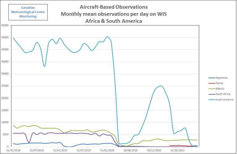
Unfortunately, particularly given the economic uncertainty and hardship in the aviation sector, we can expect that many airlines, some of which contribute to the AMDAR programmes, may not recover or may not continue to participate. This would be expected to have the greatest impact on programmes in Africa and perhaps South America. Recent reductions that can be seen for South America are related to the decline in output from the LATAM airline due to their requirement to reduce communications costs which are the chief cost associated with the operation of an AMDAR programme. The South Africa AMDAR programme also has similarly struggled as can be seen in the graphic below. |
Thanks to Program PartnersWMO and its Members are grateful to our aviation industry and airline partners for their continued contribution to the WMO Aircraft-based Observing System and the AMDAR Programme. The data that are produced from this collaboration are utilized within many meteorological applications and forecasts, benefiting aviation operations and safety, other application areas and the wider general public. For more information on aircraft-based observations data statistics visit the WMO Community Platform Aircraft-Based Observations site. |
ABOP Water Vapor MeasurementGlobal Water Vapor Measurement Summary and UpdateAircraft Based Observation (ABO) water vapour data are used especially as input for numerical weather predictions and other forecast operations. Two sensor systems currently are employed for ABO water vapour measurement on commercial aircraft worldwide: the second-generation Water Vapor Sensing System (WVSS-II) and Tropospheric Airborne Meteorological Data Reporting (TAMDAR). FLYHT Aerospace Solutions Ltd. announced the recent acquisition of the WVSS-II system. FLYHT looks forward to working with the weather community and airlines to expand the WVSS-II sensor network. FLYHT believes the global meteorological community, aviation industry and general public all will benefit from the continued production of this sensor and its high-quality data set. Additional information is available at the FLYHT website. WVSS-IIMeasurements with the WVSS-II sensor currently are conducted onboard 148 commercial aircraft worldwide. 139 of these belong to RA-IV (North America) and nine to RA-VI (Europe). The number of WVSS-II-equipped aircraft has remained unchanged since 2017. The table below shows the breakdown of WVSS-II reporting aircraft across all WMO Regions. 
UPS and Southwest Airlines operate the WVSS-II-equipped aircraft in North America and Lufthansa in Europe. |
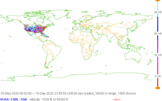
During the COVID pandemic, data loss was impacted less over North America than over Europe. While NOAA/NWS and E-ABO networks provide WVM observations predominantly from their respective regions (RA-IV and RA-VI), all participating airlines routinely travel outside the confines of their home territory enhancing the WVM data available in those data sparse areas. 
|
|
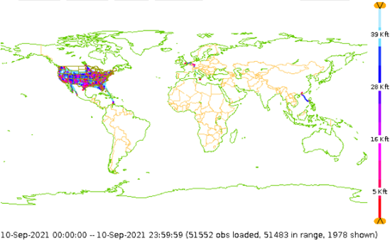
24 hours of Global WVM data from Sep 2019 (top), 2020 (middle) and 2021 (bottom) during the COVID-19 pandemic (Graphic courtesy of NOAA/ESRL/GSD) |
Water Vapor Measurement, North & Central AmericaData volumes in the WVSS component of the RA-IV ABO program continue to be only slightly below pre-pandemic levels. The 139 operational WVSS units are installed on Southwest Airlines and UPS, both of which have flown at a greater volume than other USA airlines during the pandemic and which also have a significant number of cargo flights and aircraft. Elsewhere in this article and newsletter, the provision of TAMDAR is addressed; the USA expects this data access to all WMO members to continue for the foreseeable future. We are pleased that FLYHT, Inc. has acquired the SpectraSensors production line from Endress Hauser and we look forward to soon learning more how this acquisition may impact that maintenance of the USA WVSS fleet and potential growth opportunities supported by the USA program. Water Vapor Measurement, EuropeDue to the COVID pandemic and the resulting reduction in aircraft activity, the European WVSS-II fleet (all A321 airframes) operated only on an irregular basis. After a full stop of all European WVSS-II flights during the winter of 2020/2021, three aircraft have returned to operation over the course of the spring of this year. However, the number of profiles remained relatively low with some increases during the summer vacation period. The graph below shows the variability in WVSS-II observations over almost three years. 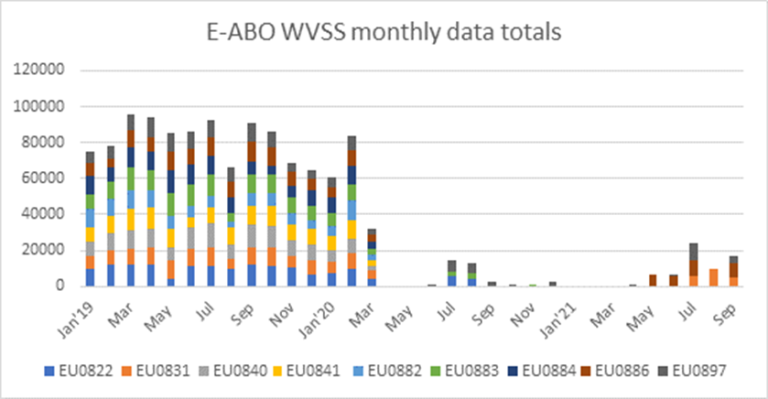
|
Compared to 2020, WVSS-II-equipped aircraft produced significantly more observations beginning in September of this year but they still lag far behind 2019 levels which can be seen in the figures below, courtesy of EUMETNET ABO. The figures show the RA-VI coverage of WVSS-II data over a one-week period (30th September - 6th October) for 2019 (left) and 2020 (middle) and 27th September – 3rd October for 2021. 
|
Lufthansa announced recently that all European WVSS-II aircraft will stop operations again in November 2021 and will be grounded until April 2022. No WVSS-II profiles over Europe can be expected during this period. The previously planned return of five of the remaining aircraft in Q4 2021/Q1 2022 will be postponed substantially but is still expected sometime in 2022. The return of the ninth aircraft only is planned for April 2023. The Met Office, UK continues planning a project to install a number of WVSS-II humidity sensors on UK-based aircraft. Delays caused by COVID have led to a reduced number of sensors being considered due to timing of available funds. A single-phase implementation of 30 sensors currently is scheduled to begin in late 2022/early 2023. Discussions with potential airlines are ongoing but as yet no firm commitment to participate has been reached. TAMDARFLYHT saw a steady increase in TAMDAR soundings over the summer months as COVID conditions improved and more people traveled during the summer holidays. However, in the past month we have experienced a slight decrease in soundings most likely due to people returning to work and school and therefore less likely to take a vacation. FLYHT believes the TAMDAR numbers will remain consistent over the next few months with a potential for growth in the sounding counts as the remaining installed TAMDAR fleet returns to service. The map below shows the TAMDAR observations for September 2021. FLYHT continues to see good data coverage over the Northwest U.S., Mexico, Asia as well as transatlantic flights. 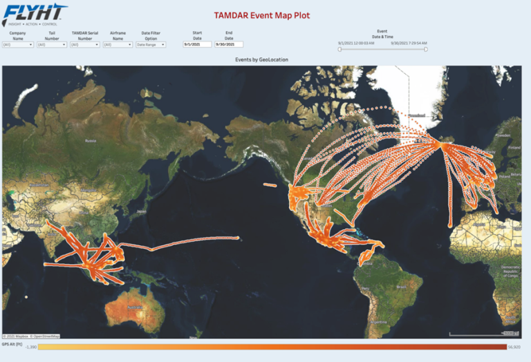
carmen [dot] emmel |
Aircraft-based Turbulence Observations Status within AMDARThere are two atmospheric turbulence intensity metrics currently in use by the AMDAR community. The first metric is eddy/energy dissipation rate (EDR). MacCready (1964) first suggested the use of EDR as a measure of turbulence intensity. It is particularly useful operationally since EDR along the vertical direction is proportional to the RMS (root-mean-square) vertical acceleration experienced by an aircraft for any given flight condition (MacCready 1964; Cornman et al. 1995). Further, EDR has been adopted as the standard metric for atmospheric turbulence reporting by the International Civil Aviation Organization (ICAO) (2001). Before the COVID-19 pandemic, more than 1300 aircraft were reporting EDR worldwide with an average of approximately 80,000 reports per day as of February 2020. However, as seen in Figure 1, which shows the approximate numbers of available routine EDR reports, beginning in March of 2020, a swift decline in the numbers of flights caused a drop in the EDR reporting to about 30% of pre-COVID-19 levels. Since then, reporting recovered slowly to about 95% of pre-pandemic levels before dropping more recently to about 90%. Figures 2, 3 and 4 show the locations of available1 EDR reports for September 2019 (before COVID-19), April 2020 (during the decline in reporting) and September 2021 (the most recent month) respectively. Currently, more than 1300 aircraft are reporting EDR worldwide with an average of approximately 65,000 reports per day. Since the number of reporting aircraft is now about the same as before the pandemic began, the lower reporting levels is likely due to an overall decrease in the number of flight hours. Indeed, comparing Figures 2 and 4, it is apparent that the number of trans-oceanic flights is significantly lower in September of 2021 compared with September of 2019. 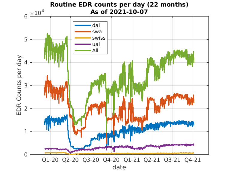
_______________________ 1 - Not all of the EDR data collected globally are yet available in this dataset. |
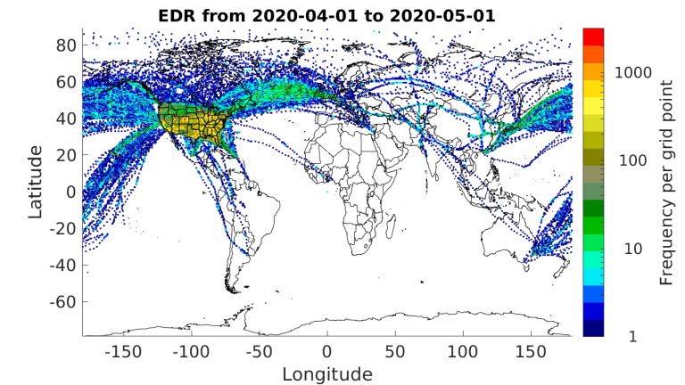
Figure 2 - Counts of all available EDR reports for September 2019 (pre-COVID-19) using an approximately 50x50 km grid. The color scale is logarithmic. |
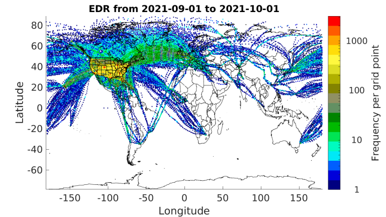
Figure 3 - Counts of all available EDR reports for April 2020 (during the COVID-19 decline) using an approximately 50x50 km grid. The color scale is logarithmic. |
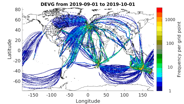
Figure 4 - Counts of all available EDR reports for September 2021 using an approximately 50x50 km grid. The color scale is logarithmic. |
The second metric, derived equivalent vertical gust (DEVG), is defined as the instantaneous vertical gust velocity which, superimposed on a steady horizontal wind, would produce the measured acceleration of the aircraft. The effect of a gust on an aircraft depends on its mass and other characteristics, but these factors are accounted for so that a gust velocity can be calculated which is independent of the aircraft. Before the impacts of COVID-19 were truly felt by the aviation industry, more than 360 aircraft were reporting DEVG worldwide averaging about 20,000 reports daily. Starting in early March of 2020, DEVG reporting also dropped significantly, down to about 15% of pre-COVID-19 levels. These numbers are based on an analysis of AMDAR data from The U.S. National Centers for Environmental Prediction’s (NCEP) Meteorological Assimilation Data Ingest System (MADIS). A large fraction of the DEVG data appears under a few tail numbers, which is unrealistic, and thus the estimated number of aircraft reporting DEVG is substantially underestimated. Currently, there are at least 150 aircraft reporting about 16,000 measurements per day (about 80% of pre-COVID-19 levels). Figures 5, 6 and 7 show the locations of all DEVG reports for September 2019, April 2020 and September 2021, respectively. There is software-based logic implemented on many aircraft that limit reporting of DEVG in some regions at certain altitudes (e.g., Europe). DEVG reporting has increased over North America but continues to have limited coverage in the southern hemisphere. 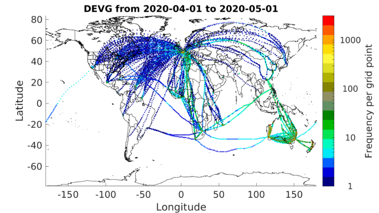
Figure 5 - Counts of all available DEVG reports for September 2019 using an approximately 50x50 km grid. |

Figure 6 - Counts of all available DEVG reports for April 2020 using an approximately 50x50 km grid. |
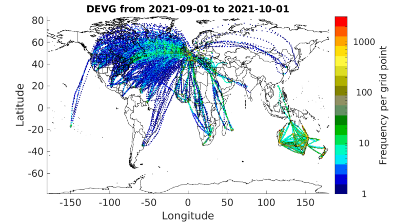
Figure 7 - Counts of all available DEVG reports for September 2021 using an approximately 50x50 km grid. |
These maps illustrate the need for expansion of aircraft-based turbulence observations in many areas of the globe. WMO continues to work with its Members and their respective national airlines to increase aircraft-based turbulence observation coverage. WMO and its Members express gratitude to our aviation industry and airline partners for their continued contribution to the WMO Aircraft-based Observing System and the AMDAR Program. The data produced from this collaboration are utilized within many meteorological applications and forecasts benefiting aviation operations and safety, other application areas and the wider general public. For more information on aircraft-based observations data statistics visit the WMO website. meymaris |
Regional Programmes Status & DevelopmentWMO Region IV (North America, Central America and the Caribbean) – ABO StatusProgrammatic DevelopmentsThe RA-IV Program consists of the USA and USA-based airlines as well as FLYHT TAMDAR and AFIRS-AMDAR. Mexico and AeroMexico, and Canada and Canadian data sources from FLYHT, Inc. also are included in the Program. Also featured in this newsletter the reader will find a more detailed article on new Canadian sources of data from FLYHT. The RA-IV program is making progress toward establishment of a regional WMO RA-IV program under the WMO WICAP framework. A Region IV Infrastructure Committee was established and in September 2021, an expert team was formed under the auspices of the committee, in part, to support WICAP with Canada representing RA-IV on the team. The USA has renewed its contracting arrangements for continued procurement of AMDAR and WVSS from USA-based airlines. Support also has continued for the procurement of data from AeroMexico and LATAM, the latter in collaboration with RA-III. Additionally, the USA has secured a longer-term agreement with FLHYT for continued provision of TAMDAR and AFIRS-AMDAR data for all WMO members. This follows the temporary arrangement in place during the COVID-19 pandemic. We are optimistic this provision will continue for at least several years. Recently , AFIRS-AMDAR volumes have increased in parts of the world with historical data voids, including Africa (AeroContractors, IBOM, Nile Air), China (China Express, DHL, Okay Airways) and Russia (Azur). 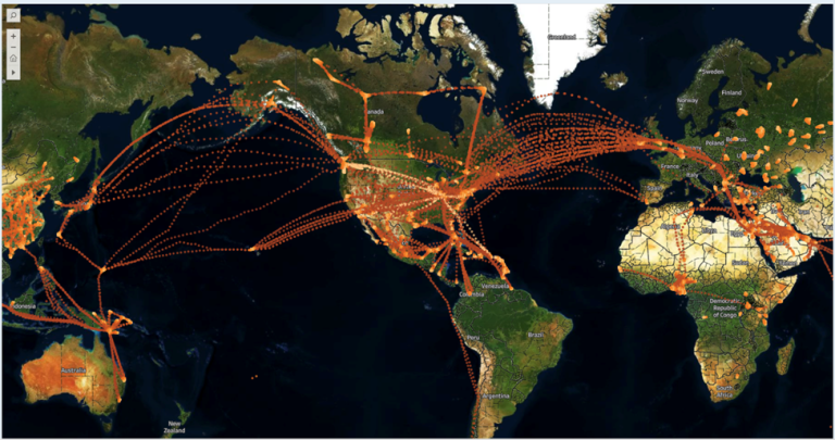
Figure 1 - AFIRS-AMDAR routes and coverage during September 2021 |
COVID-19 impacts on the RA-IV program continue to be significant but data levels have returned appreciably with the USA program now averaging, on a daily basis, around 70% of the pre-pandemic volume. However, the WVSS component continues to be near normal thanks to the large number of cargo aircraft providing data (Please see the WVM summary article for more information on WVSS). 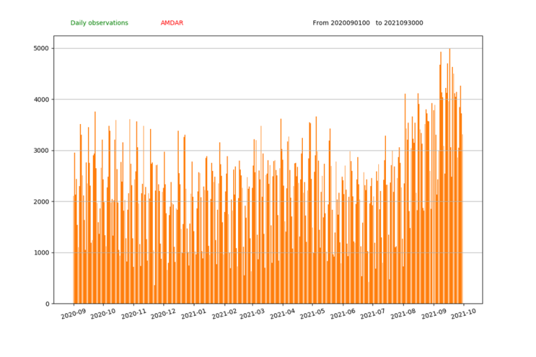
Figure 2 - Recent daily observations from the Canadian ABO program.curtis [dot] marshall WMO Region VI (Europe)ABO StatusThe numbers of ABO observations and profiles have continued to increase since March 2021 with August 2021 seeing the best area/profile coverage since before COVID-19 struck. The recovery has been led primarily by the short-haul European flights rather than from increased long-haul air travel. |
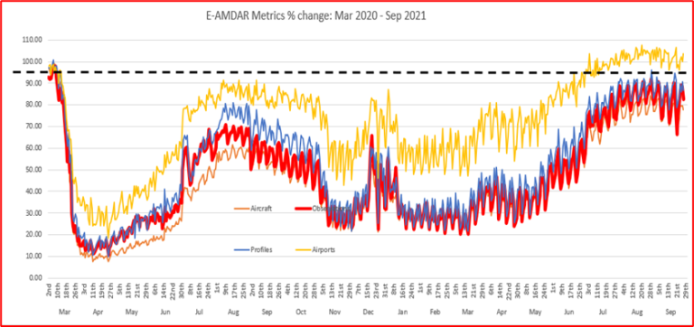
In terms of overall numbers, all types of Aircraft-based Observations collected for users within the European area have shown consistent increases over the last 5-6 months and totals now are exceeding the levels of pre-COVID observations. |

Number of observations per month by observation type |
While the number of observations currently is looking good, the summer increase has been driven by the holiday traveller. Whether this trend will continue is highly dependent on the return of the European business traveller. Global business travel is changing and it is expected that there will be many fewer business miles flown. Thanks to COVID, many are realising they don’t need to fly to a meeting which now can be held effectively by ZOOM or TEAMS! With carbon footprint also becoming a corporate issue, many (including EUMETNET members) are looking to rail for travel within Europe, especially for destinations of less than two hours! The predicted slow return of the business traveller already has prompted Lufthansa to ground most of its larger A321 fleet for the winter period. This unfortunately includes all of the WVSS-II humidity-installed aircraft. As a result, from November on, we are not expecting to see regular WVSS-II observations until they are reintroduced gradually for the summer 2022 schedule. The airline industry is clearly still in crisis mode and Europe is not expected to recover to 2019 levels until at least the end of 2023. This slowdown continues to impact advances with only those considered critical to their operations being given any form of approval by airlines. Unfortunately, this means that many of the originally planned E-ABO developments are still on hold, probably until the next programme phase in 2024/25. While developments with airlines have been severely impacted, there have been opportunities to advance the improvement of automated performance monitoring for the E-ABO programme as well as improving the out-of-hours monitoring of both data processing and fault monitoring. This should improve response times for any data outages. The AFIRS and TAMDAR data over Europe, Russia and the Middle East continue to supplement the AMDAR network. The latest plot of supplementary data provided by FLYHT (AFIRS/ TAMDAR) is shown below. 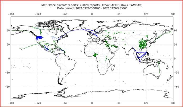
|
Over the course of the last year, the EMADDC team has made significant progress in ‘operationalising’ the EMADDC service with the release of version 2.2 which is now ready for testing and, eventually, operational use. The output of the new version contains more observations whilst having improved quality and provides data from all suppliers in a single file. Also, Mode-S MRAR data are now available as a separate product but the MRAR data are not yet quality controlled. 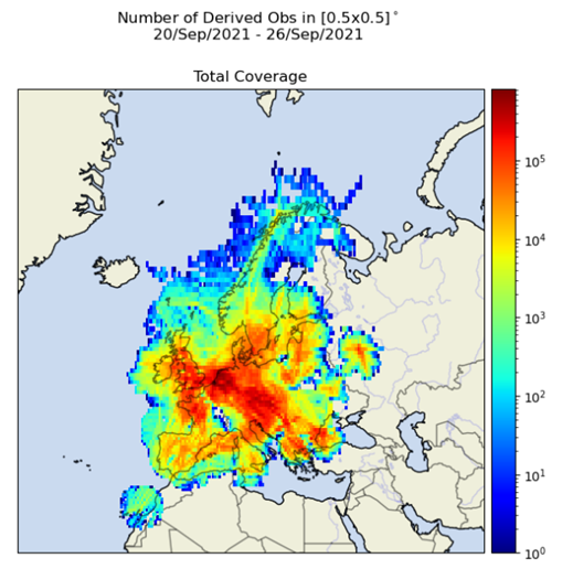
EMADDC currently is generating approximately 50 million wind and 20 million temperature observations each day with statistics showing good quality (Wind: standard deviation < 3m/sec, Temperature: standard deviation ~1°K with negligible temperature biases exhibited above FL050). Changes also have been made to the format of datafiles provided to users. Many were unable to handle large volume files as the number of observations began to grow. Data in BUFR messages now are limited to subsets of no more than 100 observations. The EMADDC website recently has been introduced to provide support to users and collaborators. This site will be expanded in the coming months to include all background documentation and will become the primary means of update and performance reporting to users. Finally, the region has finalised its latest release of the ABO-Regional Implementation Plan (A-RIP VI) and is close to finalising its regional WICAP Implementation Plan. Both plans are anticipated to be submitted to the forthcoming RA-VI Session for approval. steve [dot] stringer |
Recent WICAP DevelopmentWICAP Data Policy and ResourcingThe global development of the WMO-IATA Collaborative AMDAR Programme (WICAP) is coordinated by the Coordination Group on WICAP (CG-WICAP) which sits under the Joint Expert Team on Aircraft-Based Observing Systems (JET-ABO). The Coordination Group, which meets regularly, is comprised of WMO and IATA experts who are working toward successful WICAP implementation. The previous Newsletter Volume 21 reported on the WICAP work progress and plans following the signing of the WICAP Working Arrangement between WMO and IATA in late 2021. Since April 2021, several milestones have been achieved, of which the most significant is the signing of the WICAP Data Policy in August 2021. The decision-making body of WICAP, the Governing Board, endorsed the content of the Policy for final approval by the 73rd Executive Council (EC-73) in June 2021. The WICAP Data Policy defines the principles to support data management by securing the original data ownership by the airlines, while also ensuring that products derived from the use of AMDAR data are owned by the NMHSs. Data will continue to be available for non-commercial purposes to all WMO Members on the WMO Information System in accordance with WMO Resolutions and Technical Regulations. This is in accordance with the recently approved the WMO Unified Data Policy Resolution (Res. 1) at the Extraordinary session of the World Meteorological Congress (Cg-Ext 2021) in October 2021. According to the WMO Unified Data Policy, AMDAR data is defined as recommended data and should be exchanged globally. While the IATA Turbulence Aware (TA) data are not part of the WICAP Data Policy and will not be shared as part of the collaborative programme of WICAP, both WMO and IATA are continuing to jointly work with the extension and enhancement of AMDAR data coverage according to the WMO-IATA Working Arrangement including the collaboration on expanding turbulence data reporting and monitoring as a component of AMDAR under WICAP. After signing the WICAP Data Policy, the CG-WICAP continued to discuss the feasibility of developing a proposal on a framework for turbulence data sharing. The group recommended to the Governing Board that WMO and IATA will not take a centralized or organization level approach to exchange IATA Turbulence Aware data, and IATA will seek to establish bilateral or, if possible, multi-lateral agreements with WMO Members for access to the TA data. Based on this understanding in relation to sharing of TA data, CG-WICAP will commence finalization of the WICAP Financial Framework which will recommend cost-sharing principles for airlines and NMHS considering to join the Programme under the WMO regional programmatic framework. Regional Progress on WICAPAt the regional level, the WMO Regional Association VI (North America, Central America and the Caribbean) and RA II (Asia) recently have decided to establish regional AMDAR Programme under WICAP. As a result, all WMO Regions now have chosen to establish regional working groups for developing regional approaches for resourcing and operating AMDAR Programmes. Recently, four Regional Associations have conducted sessions with the following actions related to WICAP:
The Coordination Group on WICAP continues the establishment and development of the WICAP Framework with several priority activities for 2021/2022 that include:
More information: WICAP on the Community Platform mhuuskonen |
WMO Uncrewed Aircraft Systems Demonstration CampaignFollowing a decision of the Infrastructure Commission first session (Part III) in April 2021, the Joint Expert Team on Aircraft-Based Observing Systems is developing the terms of reference, scope and plan for a demonstration campaign on Uncrewed Aircraft Systems (UAS) to be coordinated by WMO and INFCOM, likely commencing in the second half of 2023. While the scope of the campaign still is being elaborated fully and will be subject to endorsement the INFCOM and its relevant Standing Committees, the INFCOM has agreed that the primary concept associated with the campaign should be to demonstrate the capability of UAS to provide data of sufficient quality and reliability on a routine operational basis in support of meeting requirements for upper-air observations as a component system of the WIGOS Global Basic Observing Network (GBON). Following the WMO Workshop on Use of Unmanned Aerial Vehicles (UAV) for Operational Meteorology, 2-4 July 2019, Toulouse, France, it has become clear that the potential for UAS to play a role in operational meteorology as a component observing system in the next 5 to 10 years is a real possibility. Indeed, UAS are not a new technology and they have been used in research campaigns and for specific non-operational meteorological, hydrological and environmental applications and observing campaigns for several decades now. However, in recent years, these systems have moved much closer to achieving the technical capability to function with near full autonomy and to provide accurate measurement of many key weather variables including air temperature, humidity and wind. Additionally, with the advent of low-cost componentry and efficient energy solutions, and as the use of drone and small unpiloted aircraft increases and broadens to accommodate a range of applications and roles in other sectors, the cost of such systems and their production and operations for use is gradually decreasing. These parts of the campaign aim to demonstrate these capabilities and identify any gaps and deficiencies. The campaign will demonstrate the end-to-end capability of UAS to contribute observations as a component system of the GBON. There will be an important role for data users and researchers, particularly in numerical weather prediction, to access and make use of the observations both during and after the campaign to assist with analysis and measurement of data quality and impact. The provision of a data representation standard and associated processes to enable data provision by participant UAS operators therefore also will be a critical component. Recent work in the development of the WMO Information System version 2.0 will be leveraged. The involvement of ICAO and national airspace regulators and managers also will be important to provide required permissions and ensure correct adherence to regulatory requirements by operators. An important outcome of the campaign will be to analyse results from all components of the end-to-end system, including UAS operational performance and capabilities, quality of data outputs, impact on user applications and the environment and regulatory aspects. A WMO Community Platform site has been established for the UAS Demonstration Campaign and the WMO soon will commence communication with Members and other potential participants and partners regarding their possible involvement in the campaign. The final draft version of an article soon to be published in the Bulletin of the American Meteorological Society is available and describes in more detail the state of readiness of UAS to contribute to operational meteorological monitoring. Research agencies and private entities that might be interested in participating in the UAS Demonstration Campaign can complete a brief questionnaire and register their interest from the UAS-DC site. A survey of WMO Member agencies also has been undertaken to gauge interest in their participation. WMO can be contacted about the campaign via the email address uas-demo |
EMADDC UpdateAbout EMADDCThe European Meteorological Aircraft Derived Data Center (EMADDC) is a component of the EUMETNET Aircraft Based Observation Programme and is operated by the Royal Netherlands Meteorological Institute (KNMI). EMADDC’s objective is to obtain as many high-quality meteorological upper-air observations across the whole of Europe as economically as possible. This is accomplished by operating a service tasked with collecting, processing and disseminating aircraft derived data such as Mode-S, Enhanced Surveillance (EHS) and Meteorological Routine Air Report (MRAR) thereby providing quality-controlled upper-air observations of temperature, wind direction and speed. Modern aircraft carry sensors to measure the Mach number (using a pitot static probe) and air temperature (T). An enhanced surveillance air traffic control radar interrogates, in a selective mode (Mode-S), all aircraft in range. These aircraft reply with a message containing, for example, magnetic heading, airspeed and Mach number. The messages are collected by Air Traffic Control or by a network of local receivers. EMADDC has developed algorithms to derive calibrated and quality controlled meteorological observations from these messages. StatusA new phase in the development of EMADDC has begun. This has resulted in the release of version 2.2 and the introduction of a new website, https://emaddc.com. The output of version 2.2 contains more observations whilst improving data quality. It also provides data from all suppliers in a single file. Also, MRAR data are now available as a separate product but they are not yet quality controlled. In January 2022, both EMADDC version 1.6 that currently is processing MUAC data and version 2.1 that was introduced to mitigate the COVID-19 situation (see Newsletter Volume 19, May 2020) will be decommissioned. The figure below provides an overview of both the total and individual geographical coverages per data stream. The Air Support data (not shown as an individual stream) are included in the total coverage. 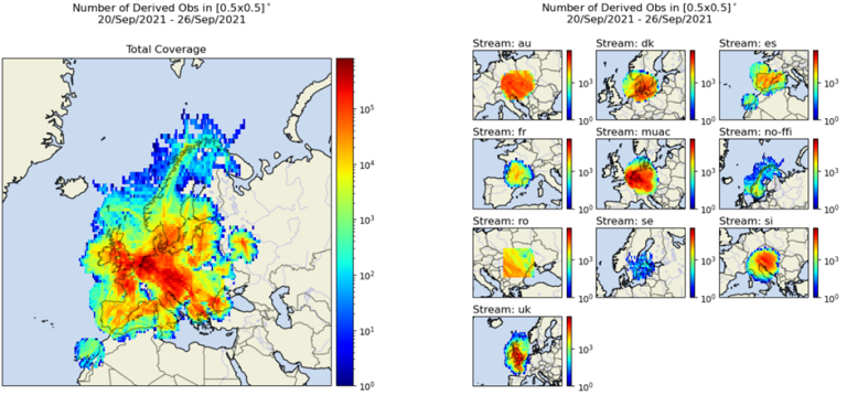
Data AvailabilityData currently are being made available to EUMETNET Members and ECMWF via Secure File Transfer Protocol (SFTP). A data portal will be developed in 2022 to enable users to retrieve the EMADDC data. Upgrades in 2022 aim to increase the geographical data coverage. They also will improve the data quality and quality control process as well as improve near-real-time processing and methods of data collection. To receive regular updates of the EMADDC developments visit the EMADDC website or register to the news section on https://emaddc.com. On behalf of the EMADDC team, jan [dot] sondij |
Availability and Impact of FLYHT DataFollowing from the article in the Newsletter October of 2020 (Volume 20), an update is provided on the status of the data provision from FLYHT. You will recall that we began receiving data from both the Automated Flight Information and Reporting System (AFIRS) and the Tropospheric Airborne Meteorological DAta Reporting (TAMDAR) system during April of 2020. Since then, the number of reporting aircraft has increased along with the associated data volumes. FLYHT currently has 127 active TAMDAR and 195 active AFIRS-reporting aircraft (based on a September 2021 summary report) with the highest concentration of TAMDAR flights over North America and the greatest number of AFIRS over Asia. FLYHT has informed JET-ABO that there are plans to activate an additional 60 AFIRS-equipped aircraft over the next several months. From Figure 1 we can see the evolution of the FLYHT data provision. 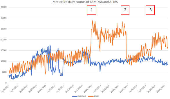
Figure 1 - FLYHT data volumes since April 2020. There has been some variation to the AFIRS data volume which can be explained as follows, Box 1 indicates the addition of Chinese regional data, Box 2 relates to issues with Chinese data provision and Box 3 shows the gradual recovery of the Chinese data which still haven’t reached previous levels. The TAMDAR volumes are stable and currently running at about double the initial levels. |
Figures 2 and 3 below depict AFIRS and TAMDAR data coverage for the period September 1st through 30th of 2021. 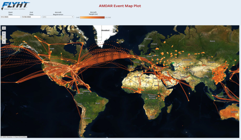
Figure 2: AFIRS global coverage for September 2021. The image clearly shows the regional data coverage over Canada, eastern Europe, Asia and Africa (courtesy of FLYHT). |
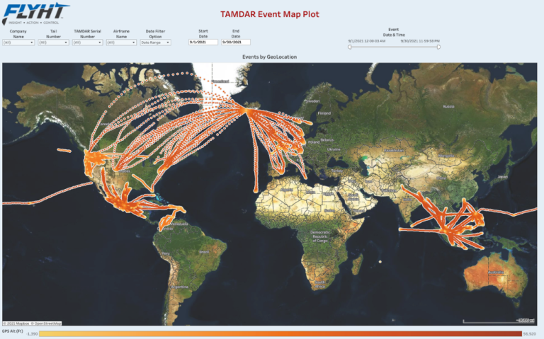
Figure 3 - TAMDAR global coverage for September 2021. Of note is the data provided from the Iceland-based airline providing information over the data sparse regions of the Atlantic (courtesy of FLYHT). |
FLYHT now is providing data coverage over all WMO Regional Associations, as can be seen in Figure 4. 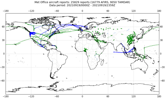
Figure 4 - Global coverage of AFIRS (green) and TAMDAR (blue) 19th September 2021. |
When looking at a data coverage plot across all ABO platforms, we see the supplementary benefit from the FLYHT data. 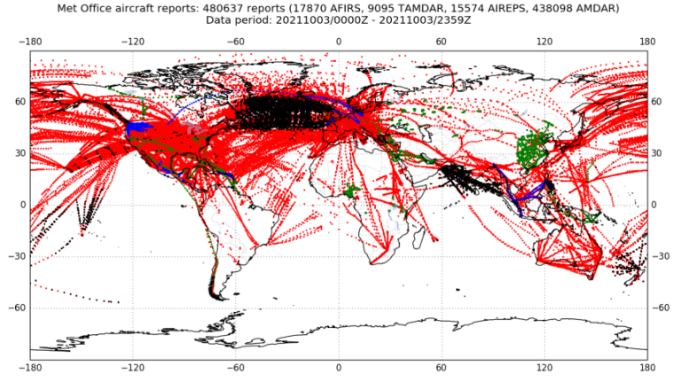
Figure 5: Aircraft based observations (ABO) coverage 3rd September 2021 (courtesy of Met Office, Data Assimilation). AMDAR data red, ADS-C data black, AFIRS data green and TAMDAR data blue.In summary, the data from FLYHT are supplementing the other ABO platforms as well as providing valuable information to regions where upper-air data is are sparse. As of yet, no specific impact studies have been carried out by the MET community. However, several NWP and data centres, along with NMHSs, are assimilating the AFIRS and TAMDAR data. The JET-ABO Expert Team has requested that those organisations assimilating the data provide feedback on data usage and any benefits seen to NWP model products and/or forecasting performance. This information will be used as part of the business case for continued data provision. FLYHT data will continue to be available to users until April of 2022 by way of U.S. NWS funding. Discussions during the first quarter of 2022 will be required to ensure funding of the data continues. stewart [dot] taylor |
AMDAR Data in WFO Phoenix During Monsoon OperationsMonsoon season in the Desert Southwest region of the United States is notoriously difficult to forecast. During the monsoon, an upper-level high typically sets up near the Four Corners region of Arizona, Utah, Colorado and New Mexico. Deep southerly flow increases moisture transport from the south leading to increased rainfall. The monsoon typically is characterized by conditional instability, weak gradients and indistinct mesoscale features. Minor differences in environmental parameters can make the difference between a non-event and a significant severe weather outbreak. Twice daily radiosondes generally are insufficient to capture crucial mesoscale details. The use of AMDAR soundings has been important at WFO Phoenix for several years as they allow for high temporal resolution of the evolving atmosphere and can give important information to help steer convective forecasts between the standard sounding times. One concern with AMDAR data is that aircraft do not sample the same airspace, meaning they may arrive from differing directions and may not descend uniformly upon approach. As would be expected, this can lead to large variations between soundings, thereby casting doubt on any particular interpretation. To address this issue and better utilize AMDAR data, WFO Phoenix has developed a program to download, QC and post-process these data. The data then can be viewed in bulk and examined in ways that would never be possible with individual soundings. Some of the ways that data are grouped includes composite sounding plots for 1, 2 and 3-hour periods (see Figure 1 which depicts a 1-hour composite plot). Useful derived variables and a hodograph are plotted along the side of the soundings. Data also are grouped to compare how the soundings had evolved over 1, 3, 6, 12 and 24-hour periods. This is particularly useful for comparing how the atmosphere has evolved to assess whether convection is likely on a given day. A Velocity Azimuth Display (VAD)-like wind profile plot has been extraordinarily useful for viewing changes in the wind shear profile. Time series plots showing the evolution of derived variables that are known to be valuable in monsoon forecasting also have been helpful. Some examples include Convective Available Potential Energy (CAPE), low-level mixing ratio, lapse rates or wind shear. The 2021 monsoon season was one of the most active on record for WFO Phoenix with numerous cases where AMDAR soundings improved difficult forecasts. One such example was from August 13-14, 2021. The forecast leading into this event only gave a 30-40% chance of rainfall around the Phoenix area. The atmosphere was characterized by significant instability and wind shear, but whether or not a modest stable layer near 800 hPa would break was in question. 00 UTC 14 August 2021 AMDAR soundings showed a strong stable layer remained (Figure 1). Although some convection had formed in the general vicinity, it was weak and quickly fell apart. By 02 UTC, however, AMDAR soundings showed a significant erosion of the capping inversion (Figure 2). This was caused by a somewhat warmer and deeper mixing layer. We now had confidence that any outflow boundary moving into the area likely would produce convection. Just two hours later, multiple outflow boundaries from severe convection north of the area moved in with widespread convection developing right over the city. Numerous severe thunderstorm and flash flood warnings followed. Being able to view the convective evolution in high temporal resolution was invaluable to assessing the convective trends of the evening and greatly increased our confidence that severe convection would develop. 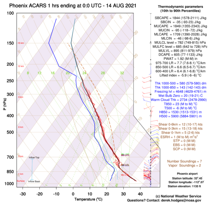
Figure 1. Aircraft Meteorological Data Relay (AMDAR) into and out of Phoenix for a one-hour period ending at 00 UTC 14 August 2011. The temperature profile mean is plotted in black with individual soundings shown in red. Similarly, the dew point profile mean is plotted in blue with individual soundings shown in green. The effective inflow layer is annotated in the bottom left corner. The mean wind profile is plotted along the right-hand side of the plot and is colored according to the disagreement between the soundings. Blue to green colors indicate little uncertainty but orange to red indicate high uncertainty. Numerous derived variables are plotted along the far-right portion of the plot with the 10th and 90th percentile of those variables indicated in the parenthesis. Missing values are denoted with an ‘M’. |
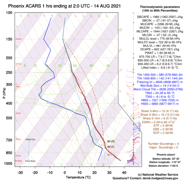
Figure 2. As in Figure 1, but for 02 UTC 14 August 2021.derek [dot] hodges |
B787 Winds and Other Aircraft Data Quality IssuesIn late 2017 a problem was noted at the European Centre for Medium-Range Weather Forecasts (ECMWF) with a subset of aircraft winds over the North Atlantic. Figure 1 shows a more recent example of a similar situation. To summarise what we know now: where the true wind is in the southerly quadrant, Automatic Dependent Surveillance-Contract (ADS-C; cruise-level oceanic data) reports from Boeing 787 aircraft indicate an erroneous direction, so that the southerly component is reversed. Many of the ADS-C reports are over the North Atlantic and on days with strong southerlies at cruise level over part of this region, there are many ‘bad’ winds. However, on other days without southerly winds, the number of problem winds is much lower. Because it can affect winds from different aircraft this issue is problematic for quality control because a buddy check (or variational quality control used at some centres) usually assumes that errors from different aircraft are independent. The other unfortunate aspect was that we had no information on airframe type (since then we have partial, but still incomplete, information on aircraft type). We understand that Boeing and its avionics partners are working on a solution, but do not know when it will be ready or how long it will take to roll out.
On 28 July 2020, ECMWF implemented a Numerical Weather Prediction (NWP) modification which included a simple ‘correction’ by reversing the v wind component when it gives a much better fit to the short-range forecast. In Figure 1, detected ‘bad’ winds are shown in red (after correction most of them are usable); most of the blue winds are ‘good’ but some have the direction error (any ‘correction’ scheme like this is imperfect). Remaining problematic winds can be rejected or down-weighted by the quality control step. The v-switch check is applied to ADS-C reports in AMDAR format (which were separated from AMDARs data at the same time) and AIREPs - some of which are ADS-C. About 90% of the ‘bad’ winds are over the North Atlantic - where there are usually enough good winds to give a good quality analysis. In the test period the change had more impact in the Southern Hemisphere. There are cases with only two tracks, both B787s, across the South Pacific to/from Australia which can cause serious analysis errors. 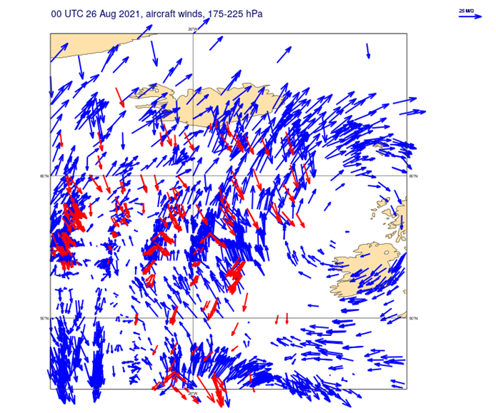
Figure 1 - Reported aircraft winds (175-225 hPa) over part of the North Atlantic for a 12-hour window in August 2021. Red winds are those detected as having the wrong v component by a check in the ECMWF NWP system. |
ECMWF monitors all the observations used twice a day and some of the statistics are provided at the ECMWF observations monitoring site. The monitoring includes maps showing the coverage of different AMDAR programmes and indications of quality using the ‘first guess departure.’ The forecast used as the first guess (or background) is sufficiently good that large differences usually indicate observation problems. Individual aircraft with persistently large differences are put on an ECMWF rejection list which is updated monthly. Internally, there are warning systems checking timeseries of observation statistics. On 22 August 2021 there were warnings about many different aircraft from the Chinese AMDAR program. Additional profile statistics were generated and the next day a notification of the problems with Chinese temperature and wind data was sent via the WMO ABO data monitoring email group. ECMWF and some other NWP centres rejected the data temporarily. The problem was partially resolved at source a few weeks later but the data volumes are now low and ECMWF is continuing to monitor the Chinese AMDAR data before using them again. Because aircraft travel at high speed, kinetic energy is converted to heat energy in the temperature probes. The measured temperature, sometimes called ‘total air temperature,’ is much higher than the ambient air temperature and must be corrected for the airspeed. Approximations in the avionics can lead to residual biases. Typically, the reported values are 0.5°C to 1.5°C too high but some aircraft types have slight negative biases. This accuracy is good enough for the airlines but not for NWP systems and most apply their own bias correction to the reported temperatures (based on aircraft identifier). Although this works moderately well, the performance of such bias correction schemes depends on: a) forecast model biases and b) having a good proportion of ‘anchor’ observations that do not require bias correction. In the long term it would be much better if the temperatures were provided with very little bias from the on-board processing (which has access to the airspeed and other relevant variables). A step in this direction has been demonstrated by de Haan et al (2021, AMTD). 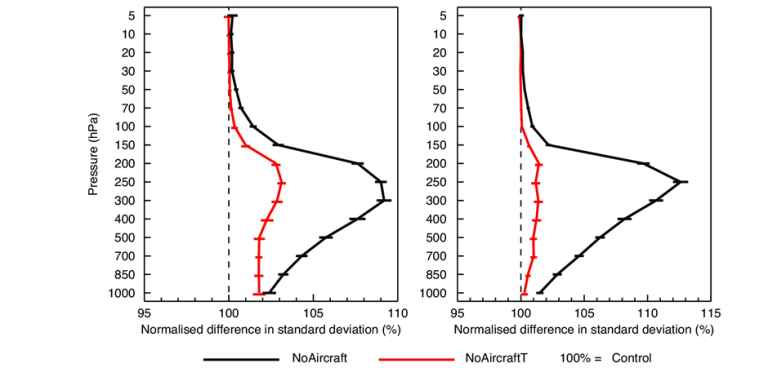
Figure 2 - The impact on 12-hour forecast departure statistics for radiosonde temperature (left) and radiosonde wind (right) for latitudes 20°N-90°N. The black line depicts an experiment with no aircraft data, the red line shows an experiment without aircraft temperature - both normalized by control values. The horizontal bars show 95% confidence intervals. Results of ‘data denial tests’ run at ECMWF for the period 28 January to 30 April 2019 (Ingleby et al, 2021, GRL).References: de Haan, S., J. van der Meulen, and P. de Jong, 2021: Characterizing and Correcting the Warm Bias Observed in AMDAR Temperature Observations. Atmos. Meas. Tech. Ingleby, B., B. Candy, J. Eyre, T. Haiden, C. Hill, L. Isaksen, D. Kleist, F. Smith, P. Steinle, S. Taylor, W. Tennant, and C. Tingwell, 2021: The Impact of COVID-19 on Weather Forecasts: a Balanced View. Geophys. Res. Let. bruce [dot] ingleby |
Contacts | |
WMO INFCOM, Joint Expert Team on Aircraft-Based Observing Systems Contacts Chair Vice-chairs nrivaben | WMO AMDAR Observing System Newsletter Editor ceweiss1949 WMO Aircraft-based Observations dlockett mhuuskonen |

