Guide to Operational Weather Radar Best Practices Poster
Vol I - Weather Radar Network DesignTarget audience: Upper management, decision makers, funding agencies | |
Weather radars are arguably the most expensive and most complex instruments within operational National Meteorological and Hydrological Services. They strengthen, enable, and indeed can revolutionize the services provided by NMHSs to economically and socially benefit society. Part A provides a guide to the development of an end-to-end radar program.Required competencies include: Project leadership and management, meteorological, engineering, support and maintenance, R&D.Costing: estimates are needed for the complete life cycle, which can be 15-40 years, divided into program phases. Annual estimates also needed.Radar project is also distinguished from the program as a limited time endeavour with well-defined scope and resources, e.g. an upgrade.Network design includes choice of technology, deciding how many and where to install radars, all in relation to user requirements, potential advantages from collaborative networking domestically and internationally, and contributing towards integrated observing systems and networks. | 
|
Vol II - Weather Radar TechnologyTarget audience: Decision makers, managers, engineering and technical practitioners, scientists | |
A complete weather radar system consists of combined technological solutions that provide information supporting well-defined user requirements.As such, the system comprises: the radar instrument, radome, tower, personnel and equipment shelter(s), power, reserve power, ancillary systems (e.g. climate control, lightning protection, security), communications, control and data processing software, computational resources, data storage/archive.Strategic decisions on weather radar technology need to be made on: wavelength (for operational systems commonly X, C, or S bands), transmitter type (magnetron, klystron, solid state), beam width, sensitivity, “type”. Today, polarimetric (or dual-polarization) technology is established as the mainstream weather radar type. It is difficult to buy a weather radar that does not have polarimetric and Doppler capabilities.Examples of emerging weather radar technologies are pulse-compression techniques (already common in places) and phased array antennas. | 
|
Vol III - Weather Radar ProcurementTarget audience: Decision makers, managers, procurement specialists, engineering, technical, and scientific support to the procurement processWhen you go shopping for a weather radar, how can you be sure you will really get a weather radar and not something else? Can you be assured that your new radar will have relevant, contemporary, and up-to-date features? The objective of Part C is to describe and provide examples of different approaches to weather radar procurement.The greatest challenge when implementing weather radars will be that of human resources (availability of highly qualified people) and intellectual capacity (technical and meteorological). Training and other capacity building activities need to be part of strategic planning on a 5+ year time scale and be included in the radar procurement or project.Included in weather radar procurement (other than radar instrument): infrastructure and civil works, project management, warranty period, support and maintenance, different levels of training, responsibility for configuration/data quality, acceptance testing, spares, life-cycle management, upgrade plan, integration with NMHS infrastructure, software/application development, auxiliary meteorological sensors (on/off site). | |
Vol IV - Weather Radar Siting, Configuration and Scan StrategiesTarget audience: People who are in the process of getting their first weather radar.Congratulations! You have money to buy a radar, and you know roughly where the radar should be. This Volume of the BPG walks you through how you know you have the right hill (site and access road), how you make sure your radar can measure when it is up and running (horizon and permissions), how to get the radar data to its users (telecommunications) and how to keep it running even when thunderstorms cut off your normal power supply. And it gives you suggestions for how to measure: scan strategy is always a compromise.Some estimated numbers, underlining the importance of this part: cost of the tower and other site infrastructure constitutes a significant proportion of the radar purchase cost. Cost of keeping the radar running is annually 5-10% of the purchase cost.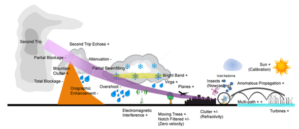
| |
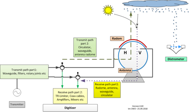
Vol V - Weather Radar Calibration, Monitoring and MaintenanceTarget audience: Operations, monitoring and maintenance practitioners and plannersWeather radars are observation equipment designed to deliver quantitative data about hydrometeors in the atmosphere, including their location in 3-D space. Calibration is required to interpret the returned pulse (power, phase) and ensure that antenna pointing accuracy is within specified limits. Phase and power calibration require measurement of losses and phase shifts through components within the transmit and receive paths. In addition to this legacy calibration, for dual-polarization radars extra calibration and monitoring should be performed using external sources, for example, solar radiation (receiver and pointing), ground-based disdrometers, ground clutter and/or space-based radar. Continuous monitoring of radar system performance may be useful for scheduling additional preventative maintenance, prolonging the life of components. (Preventive) maintenance is the basis for high availability and covers not only electrical and mechanical, but also analog components as well as IT. | |
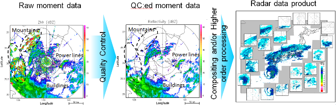
Vol VI - Weather Radar Data ProcessingTarget audience: radar operators, radar engineers, radar application developers, radar data product users
| |
Vol VII - Weather Radar Data Representation and International ExchangeTarget audience: Decision makers, IT experts, radar application developers, radar data users | |
This Volume provides guidance on the representation of weather radar polar sweep and volume data in the standardized FM301-CfRadial2 format, including identification of the data types and associated metadata which are required to support a broad range of operational and scientific applications. FM301 was published in the WMO Manual on Codes (No. 306) in 2023. | 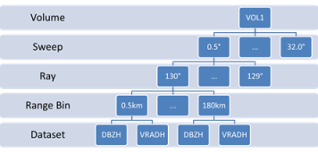
|
Vol VIII - Operational Weather Radar Glossary of TerminologyThis Volume may complement existing resources like the AMS Glossary and potentially a new WMO Standard Vocabulary, to help with experience sharing and technological transfer. | |