WMO ABO Newsletter - Volume 27
- Author(s):
- ET-ABO and WMO Secretariat

WMO Aircraft-Based Observations Newsletter
Volume 27, December 2025
Contents
- Welcoming Remarks
- Global Aviation Stakeholders on ABO Meeting and Expert Team on Aircraft-based Observations Meeting
- Status of Aircraft-Based Observations Programme
- Regional Programme status and developments
- Aircraft-based Turbulence Observations Status within AMDAR
- ABOP Water Vapor Measurement Status
- ABOP Aircraft Derived Data and Third-party Data Status
- The Kenyan AMDAR Programme
- The 2024 WMO UAS Demonstration Campaign
- Assimilation of Global Mode-S Data Brings Major Forecast Benefits
- The Benefits of Reporting and Using GNSS Altitude from Aircraft
- Closing Thoughts: Back to Normal, Slowly…
Welcoming Remarks
On behalf of the ET-ABO Chair, vice-chairs and the WMO Secretariat, welcome to the October 2025 edition of the WMO Aircraft-Based Observations Newsletter. The World Meteorological Organization (WMO), in conjunction with the Expert Team on Aircraft-Based Observations (ET-ABO), proudly hosted the long-anticipated Global Aviation Stakeholders Meeting in Geneva, Switzerland from 15–17 September 2025. This landmark event brought together aviation experts, meteorologists and data specialists from around the world to strengthen collaboration and advance the future of aircraft-based observations.
Immediately following the stakeholders meeting, the ET-ABO held its first in-person team meeting from 17–18 September 2025 marking a significant milestone in the team’s operational engagement. The WMO Secretariat played a pivotal role in ensuring the success of both gatherings. A heartfelt appreciation is extended to all participants - whether attending virtually or in person.
Detailed summaries of both meetings can be found also in this website.
This edition of the newsletter also highlights the continued growth of ABO data driven by the expansion of AMDAR fleets and the integration of innovative data sources including aircraft derived data and third-party contributions. The recent WMO Uncrewed Aircraft System (UAS) Demonstration Campaign has opened promising avenues for systems to contribute operationally to global observation networks.
Readers will find a wide-ranging selection of articles covering contemporary topics and technical developments including:
- Status of WMO ABO Programmes
- Water Vapor Programme
- Aircraft-Based Turbulence Observations
- Aircraft Derived Data and Third-party Data
- Use of the MADIS AMDAR Website
- Expansion of the Kenya AMDAR Programme
- GNSS Altitude as the Vertical Coordinate for Aircraft Assimilation
- WMO Demonstration Campaign Follow-Up
The ET-ABO Chair, Co-Chairs and WMO Secretariat extend their sincere thanks to all authors and contributors for their time, expertise and dedication with particular thanks to the newsletter editor, Mr. Carl Weiss, for his splendid editing work over the years. Readers are encouraged to share feedback by reaching out to the authors or newsletter coordinators using the contact details provided. Special thanks also go to Nicolás for the effort it took to coordinate two global meetings at once. Together, we continue to elevate the impact of aircraft-based observations in meteorology and aviation safety.
Finally, as I exit from the Kenya meteorological service, I sincerely want to thank the ABO community for the collaboration and support during my tenure as co-vice chair of ET-ABO. Special thanks to Curtis, Carmen and Nicolás for their outstanding leadership and encouragement. It’s been an honor to contribute to this shared mission and vision.
anguluhg meteo [dot] go [dot] ke (Humphrey Angulu), co-vice Chair ET-ABO
Global Aviation Stakeholders on ABO Meeting and Expert Team on Aircraft-based Observations Meeting
From September 15 to 17, 2025 the World Meteorological Organization (WMO) hosted the Global Aviation Stakeholders Meeting on ABO (GASM) at its headquarters in Geneva, Switzerland. This was followed by a meeting of the Expert Team on Aircraft-Based Observations (ET-ABO) between 17 to 18 September. The hybrid events (in person and virtual) brought together over 70 participants from national meteorological services, airlines, aircraft manufacturers, avionics suppliers, research institutions and international bodies including the International Civil Aviation Organization, the International Air Transport Association and the Radio Technical Commission for Aeronautics.
These meetings marked a pivotal effort to reinvigorate global aircraft-based observation (ABO) programmes following significant data declines after the COVID-19 pandemic and the recomendations of the 8th WMO Workshop on the Impact of Various Observing Systems on Numerical Weather Prediction and Earth System Prediction . The ensuing discussions emphasized the critical role of ABO data across multiple domains: ensuring aviation safety and efficiency, strengthening the upper-air coverage of WIGOS, providing essential input for numerical weather prediction (NWP), and contributing to societal resilience via Pillar 2 of the Early Warnings for All initiative. By filling upper-air data gaps, especially in Regions I and III, ABO enhances forecast accuracy thereby helping to protect lives and livelihoods from hazardous meteorological phenomena.
The consolidated recommendations and actions resulting from both meetings formed a comprehensive strategy to advance ABO. This strategy centers on three core pillars:
- restoring and strategically expanding the foundational AMDAR network,
- modernizing the global ABO framework by formally integrating new data sources like UAS and Mode-S into WMO guidance and systems, and
- strengthening cross-sector collaboration with NMHS, airlines, associations, regulators, original equipment manufacturers and data service providers.
Strengthening the WMO ABO programme will provide key recommended data for the WMO Integrated Global Observing System. This will enable NMHSs to improve their forecast products and build resilience to increasingly hazardous weather phenomena within the community and the aviation industry.
More information is available in the official site of Global Aviation Stakeholders on ABO Meeting and Expert Team on Aircraft-based Observations Meeting. A list of recommendations and actions is available here: GASM list and ET-ABO list.

Figure 1: Participants attending the Global Aviation Stakeholders on ABO Meeting from 15-17 September 2025 in WMO HQ, Geneva, Switzerland.
nrivaben wmo [dot] int (Nicolás Rivaben), WMO Scientific Officer
Status of Aircraft-Based Observations
The graphic below (Figure 1) shows the smoothed monthly average of daily aircraft-based observations which are single point measurements in space and time composed mainly of air temperature and wind speed and direction. These data have been transmitted on the World Meteorological Organization (WMO) Global Telecommunications System (GTS) since 2007. The data categories shown in Figure 2 are:
- All aircraft and all systems (black),
- From the AMDAR programme with reports submitted in binary format (BUFR, red)
- From ICAO data sources (AIREP and ADS, purple dashed), and
- From the FLYHT AFIRS system (green dashed).
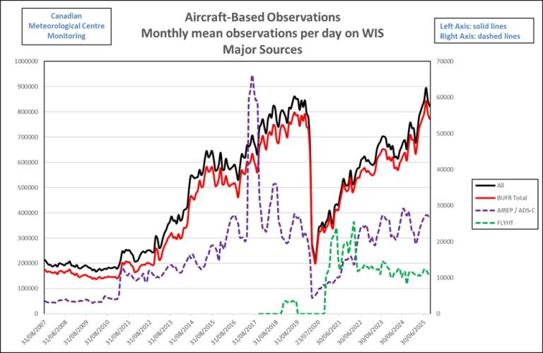
Figure 2: Evolution of major sources of ABO from August 2007 to September 2025. Source: CMC - ECCC.
These observations from the WMO AMDAR observing system are produced by 12 operational AMDAR national and regional programmes in cooperation with some 43 national and international participating airlines as listed on the WMO website.
ABO Data Volumes and Coverage
As shown in Figure 2, the number of aircraft-based observations reached a historical maximum in late 2019 and early 2020, exceeding 850k daily observations on the GTS. The majority of these were AMDAR observations which accounted for approximately 750k daily reports. With the onset of the COVID-19 pandemic in March 2020, the ensuing impact on the aviation industry led to a drastic reduction in data levels. Overall volumes fell to around 245k observations per day, while AMDAR reports, specifically, dropped to 230k representing just 30% of the December 2019 peak.
Since that period, data volumes have grown steadily surpassing 895K observations for the first time and marking a milestone by exceeding pre-pandemic levels. However, this growth is driven solely by the U.S. and European programmes. The remaining programmes are expected to surpass their pre-pandemic limits before 2027.
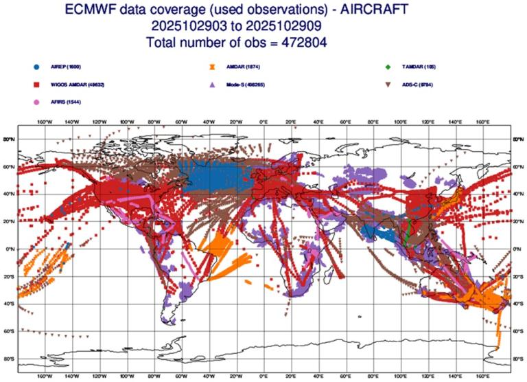
Figure 3 . Coverage ABO for 6hr on 29 October 2025. Source: ECMWF
Figure 3, provided by ECMWF, illustrates the coverage of the entire WMO ABO programme system over a six-hour period on 29 October 2025. The data incorporate AFIRS, Mode-S, TAMDAR, ADS-C, AIREP, AMDAR (FM42 – former alphanumeric encoding) and WIGOS AMDAR (FM94 BUFR – binary format). A significant expansion in coverage is evident, particularly over data-sparse regions. This increase is attributable to Mode-S data provided by a European Meteorological Aircraft Derived Data Center/Met Office programme (depicted in purple). This enhanced data coverage is expected to improve the performance of the European Centre for Medium-Range Weather Forecasts NWP models in these areas.
nrivaben wmo [dot] int (Nicolás Rivaben), WMO Scientific Officer
Regional Programme status and developments
WMO ABO Region I Update
WMO Region I (Africa) remains one of the most data-sparse upper-air regions in the world. Traditionally, these observations have relied heavily on radiosondes operated by national meteorological and hydrological services (NMHSs). However, these services are concentrated mainly across the northern and southern parts of the African continent leaving those vast areas in between without coverage.
To address this gap, the region is turning more and more to aircraft-based observations (ABO) such as AMDAR, Mode-S and ADS-C. These systems provide valuable atmospheric data from commercial aircraft offering a cost-effective way to enhance forecasting capabilities. A number of NMHSs are now leveraging ABO, with particular emphasis on AMDAR, to strengthen their operational networks.
Country Developments
Kenya
With the support of WMO, Kenya has made significant progress in expanding its AMDAR programme. Currently, four B737 Kenya Airways aircraft are operational with three more expected to join the fleet before the end of the year. Although initial plans targeted seven aircraft by June, software challenges delayed the rollout.
Despite this, the programme has grown impressively — from just 10 profiles per week at Nairobi Airport in 2024 to more than 50 soundings weekly by September 2025. The data already are being assimilated into Kenya’s numerical weather prediction (NWP) system on a trial basis using a local data processing system which is still in its early stages of development.
Morocco
In Morocco, efforts are underway to revive the AMDAR project through collaboration between Maroc Météo, Royal Air Maroc (RAM) and EUMETNET. RAM is in the process of updating its AMDAR software for technical reasons.
Recent bilateral meetings, including one with the E-ABO team in August 2025, highlighted improvements in ABO coverage over Morocco particularly through Mode-S data. A follow-up meeting is scheduled to explore financing options, assessing RAM’s B737 fleet coverage and evaluating the technical and economic feasibility of AMDAR versus Mode-S solutions.
Ethiopia
Ethiopia is still in the planning phase of its AMDAR programme. The Ethiopian Meteorological Institute (EMI), in collaboration with Ethiopian Airlines and guided by the WMO Regional Office in Addis Ababa, is exploring actively implementation pathways. EMI also is considering the establishment of a data processing system to support the programme once operational.
South Africa
South Africa benefits from extensive coverage provided by several E-AMDAR fleets which deliver a large volume of observations each month. These are complemented by data from eleven active radiosonde stations operated by the South African Weather Service. Together, these systems provide SAWS with robust upper-air profiles for operational use.
Conclusion
While progress is evident, most NMHSs in Region I still operate their NWP models without assimilating ABO data. This lack of assimilation limits forecast accuracy and hampers the full realization of a UN initiative which WMO is tasked to deliver.
By fully leveraging available ABO sources, AMDAR, Mode-S and ADS-C, Region I can improve significantly forecast reliability and strengthen the region’s early warning systems. However, since the lapse of WICAP and the regional TT-ABO, coordination has been lacking. Ongoing consultations with the WMO Regional Office aim to establish a new framework for collaboration.
The long-term vision is to transform Region I from a data-sparse to a data-abundant region ensuring that its NMHSs are equipped to deliver accurate, timely and life-saving forecasts by leveraging ABO data sources.
anguluhg meteo [dot] go [dot] ke (Humphrey Angulu), Kenya Meteorological Department, ET-ABO RA-I ABO Focal Point
WMO ABO Region II Update
ABO activities across Region II (Asia) currently face significant challenges due to declining participation in traditional AMDAR programs. Key contributors like Hong Kong and South Korea are experiencing a reduction in equipped aircraft. This loss is driven by airlines retiring older planes and showing a preference for other privately-owned initiatives over established AMDAR programmes. A point of contention is the data policy of these initiatives which does not permit the relaying of aircraft data under WMO Unified Data Policy (Resolution 1 – Cg19) to the WMO Integrated Processing and Prediction System (WIPPS). Thus, airlines’ contribution to global NWP is being reduced, especially over data-sparse areas.
Despite these setbacks, several countries, including Saudi Arabia, Oman and India, actively are exploring new strategies and technologies to sustain and enhance aircraft-based observations. China continues its data exchange via the GTS, led by China Southern Airlines, with a focus on robust quality control. Meanwhile, the Korea Meteorological Administration (KMA) and the Hong Kong Observatory (HKO) are pioneering the development of non-AMDAR data sources. KMA is advancing its use of ADS-B data to derive meteorological parameters, while HKO is investigating the use of drones and their flight logs to obtain wind and other atmospheric data, signaling a strategic shift towards innovative and alternative observing systems.
yflee hko [dot] gov [dot] hk (Yiu-fai Lee), Hong Kong Observatory, ET-ABO RA-II Focal Point
WMO ABO Region III Update
The activities of Regional Association III are aligned with the priorities established in its regional work plan focusing on the following aspects:
- Reactivation of the AMDAR program with LATAM Airlines given that its participation represents a lower cost compared to engaging a new regional airline.
- Integration into the WMO Information System (WIS) of data generated by surveillance systems in compliance with the standards of the International Civil Aviation Organization.
- Promotion of new ABO capabilities with emphasis on the use of uncrewed aircraft systems (UAS) for data collection in remote areas or areas with limited coverage.
Regarding the reactivation of the AMDAR program with LATAM, along with the support of the WMO Secretariat, coordination meetings will be conducted to explore solutions to secure the airline’s participation. As confirmed by LATAM, these coordination efforts, along with the assessment of the related costs, are currently ongoing.
In addition, the Brazilian ABO program continues sustained data collection through the ADS-C system. In 2024, the volume of processed data reached an average of approximately 50,000 messages per month with monthly peaks of nearly 80,000 messages as shown in figure 4. In 2025, a significant increase in observations has been recorded doubling those obtained during the previous year. These data were collected mainly in the Atlantic Flight Information Region (FIR-Atlântico {FIR-AO}). Furthermore, the collection of meteorological data via ADS-C within the continent already has been coordinated with the national airlines AZUL and LATAM-BR. This will increase considerably the volume of AIREP messages in the Brazilian FIRs over the coming months.
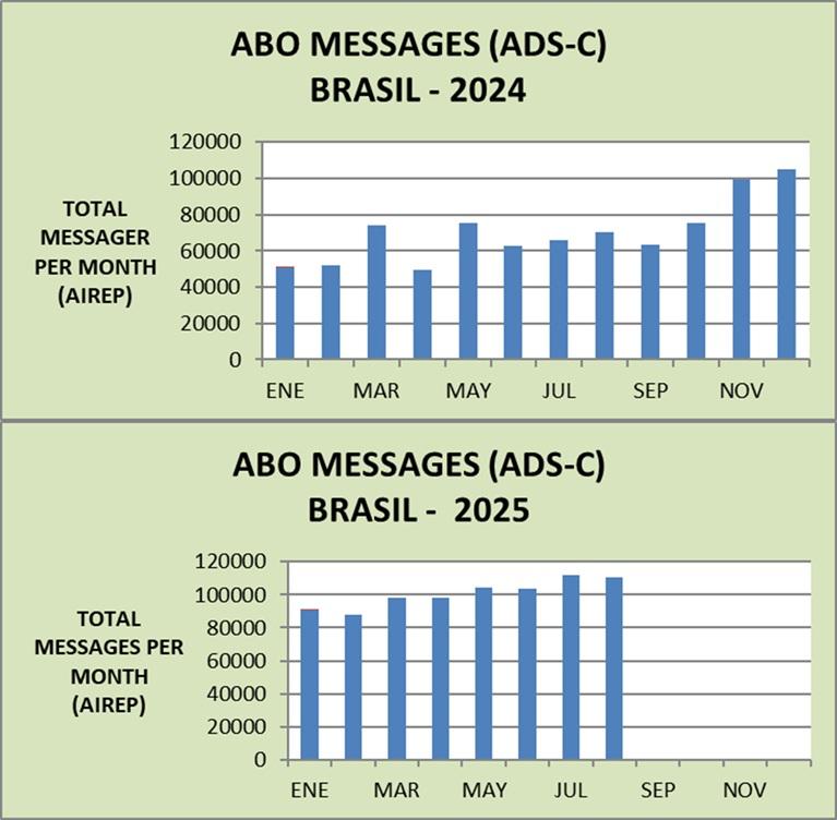
Figure 4: 2024 and 2025 ADS-C Messages from the Brazilian ABO Program. Source: DECEA/CISCEA
The Brazilian ABO program also has the capacity to process and make available to the WIS/GTS the data collected at the regional level through its National Institute of Meteorology and within the framework of its contract with SITA.
Regarding the use of UAS for ABO data collection, states in the region have initiated actions aimed at their implementation. Peru, for example, has acquired a meteorological drone (Meteodrone) and is in the process of coordinating with its civil aviation authority to obtain the necessary permits. Likewise, Brazil and Argentina have announced the start of activities to evaluate the use of these systems in the ABO domain.
hrosado mtc [dot] gob [dot] pe (Hugo Rosado Soto), Dirección General de Aviación Perú, ET-ABO RA III Focal Point and RA III Regional focal for ABO.
WMO ABO Region IV Update
The RA-IV ABO program consists of the USA with USA-based AMDAR-enabled airlines and FLYHT TAMDAR and AFIRS-AMDAR, Mexico with AeroMexico as well as Canada with Canadian data sources from FLYHT. Additionally, the USA AMDAR program provides ADS-C en-route wind and temperature reports roughly every 14 minutes on transoceanic and long-haul routes around the globe.
As of November 2025, the USA is continuing to support the WMO Secretariat and RA-I members by potentially obtaining and providing AMDAR data from Kenya Airways. The WMO Secretariat has funded additional avionics capabilities for the Kenya Airways fleet. Beginning in December 2025, the USA will purchase the data from Collins Aerospace and supply them to the GTS as part of the USA ABO feed.
The USA ABO and National Mesonet Programs secured funding through April 2026 to continue providing TAMDAR and AFIRS-AMDAR from FLYHT. The USA expects this provision to continue in perpetuity. Please see the water vapor report in this newsletter edition for an update on FLYHT TAMDAR. Additionally, the USA is working with FLHYT to fund the installation of thirty WVSS-II sensors on WestJet and other aircraft by the end of 2026.
The USA continues its partnership with the Massachusetts Institute of Technology Lincoln Labs to prototype the Portable Aircraft-Derived Weather Observation System (PADWOS) for obtaining Mode-S wind and temperature observations at select locations in the USA. Please see the article on aircraft derived data in this newsletter edition for further information.
Canada is working actively to expand its ABO capability through partnerships with data providers and airlines. Unfortunately, this complex task is taking more time than expected. As a mitigation for the recent decrease in aircraft participating in the ABO-Canada program as well as for sustaining the program itself, Environment and Climate Change Canada (ECCC) continues to develop a continuity plan targeting the capacity of Jazz's CRJ-900 fleet in order to maintain the supply of ABO data across Canada.
Discussions between ECCC, Jazz and Collins Aerospace have been underway since the summer of 2024. The expansion objective remains to prioritize the northern latitudes which are recognized as areas with poor ABO and upper-air data coverage. ECCC continually is exploring other sources of ABO data for its NWP ecosystem including new data from FLYHT through its partnership with Air North.
Curtis Marshall, ET-ABO Chairman, USA AMDAR Program Lead
Frederic [dot] Lenormand ec [dot] gc [dot] ca (Frédéric Lenormand), Canadian AMDAR Program Manager
WMO ABO Region V Update
Aircraft-Based Observation (ABO) data across WMO Regional Association V (South-West Pacific) has rebounded to pre-pandemic levels, marking a significant recovery. Despite this progress, a substantial data gap persists, with over 50% of the region remaining without coverage from the Aircraft Meteorological Data Relay (AMDAR) programme. This shortfall is primarily attributed to two factors: the limited number of AMDAR-equipped aircraft operating in the region and the scarcity of flights over its vast oceanic areas, which constitute 59% of RA-V.
To mitigate the shortage of equipped aircraft, key initiatives are being pursued. The New Zealand MetService is actively working to enhance automated weather reporting from Air New Zealand flights. In parallel, the region is evaluating supplementary data sources, such as Aircraft Derived Data (ADD) from the European Meteorological Aircraft Derived Data Centre. While ADD does not reduce the geographical data void—57% of RA-V still lacks any aircraft-based observations—it improves temporal data density (figure 5). Analysis shows the area receiving more than eight hours of daily coverage has increased from 5% to 14%. Encouragingly, the Australian Bureau of Meteorology has begun assimilating this data into its NWP systems, with promising initial results.
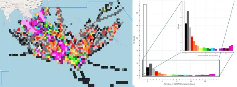
Figure 5: Status of the ABO programme coverage over WMO Region V at different times of the day.
Addressing the fundamental challenge of sparse air traffic requires a strategic, collaborative approach. The upcoming RA-V Working Group on Infrastructure (WG-INF) will establish an expert team dedicated to facilitating the implementation of national and regional ABO programmes. This team will also promote the integration of innovative third-party data sources, in full alignment with the WMO Unified Data Policy. Through these coordinated efforts, RA-V is building a more resilient and comprehensive observing network to serve vital forecasting needs across the South-West Pacific.
douglas [dot] body bom [dot] gov [dot] au (Douglas Body), Bureau of Meteorology, ET-ABO RA-V Focal Point
WMO Region VI Europe ABO Update
The EUMETNET ABO (E-ABO) programme manages aircraft-based observations for Europe with a focus on the EUMETNET Composite Observing System (EUCOS) domain (Figure 6-a). During this programme phase, which runs from 2024 to 2028, the E-ABO programme is being managed by the Met Office in partnership with the Royal Netherlands Meteorological Institute (KNMI) and Germany's National Meteorological Service (DWD). KNMI, through its European Meteorological Derived Data Centre, is responsible for the operation and development of derived ABO from Mode-S EHS data over Europe and now processes global Mode-S EHS data on behalf of the Met Office. More national meteorological services in Europe are assimilating Mode-S EHS derived winds and temperatures into global and regional NWP models including the new global dataset which has been shown to improve NWP accuracy. Further information on Mode-S EHS derived ABO and recent developments are given in the aircraft derived data report found in this newsletter edition.

Figure 6-a: E-ABO AMDAR coverage for one day
Our focus remains on improving coverage over data sparse areas within the EUCOS domain and continues to pursue opportunities for additional ABO data over the Azores for example. The AMDAR network has seen a steady growth in data availability as flight schedules have increased. About 50 easyJet aircraft were reactivated in the spring of 2025 which improved coverage particularly over Cape Verde and Georgia where ABO data are less dense. Three Airbus A330 aircraft also were added to the Turkish Airlines AMDAR fleet bringing improved coverage to destinations in Russia, Syria and North Africa. Figure 6-b shows the monthly data totals for ABO in the EUCOS domain over the past 12 months (note the different scale for Mode-S derived data!).
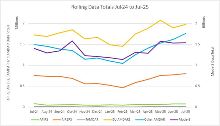
Figure 6-b: Monthly ABO totals for the EUCOS domain.
The additional Global Navigation Satellite System (GNSS) height data from KLM and the corrected British Airways observations have been tested by the European Centre for Medium-Range Weather Forecasts (ECMWF). ECMWF is keen for more AMDAR airlines to report this parameter in the future to support NWP (Figure 6-c). Scandinavian Airlines is updating their AMDAR software on a new fleet which should include a higher resolution data format and GNSS height to improve quality. The fleet update created a reduction in SAS AMDAR data during 2025, but we expect coverage to improve later in the year as AMDAR software is installed on the new fleet.
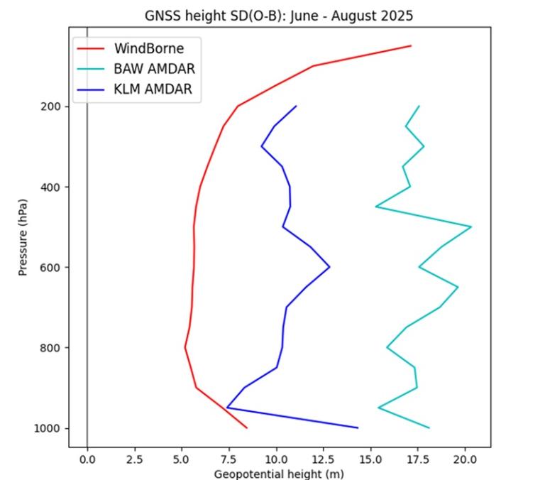
Figure 6-c: Standard deviation of height differences in geopotential meters (gpm) as a function of pressure, 50 hPa bins, June - August 2025 (differences over 70 gpm were excluded from the statistics). Also included on the graph are results from the Windborne balloon system. Source: B. Ingleby (ECMWF)
The European area continues to receive ABO data from other sources such as ADS-C and AIREPs (Figure 6-d) with a small amount of AFIRS, AMDAR and TAMDAR observations (Figure 6-e).
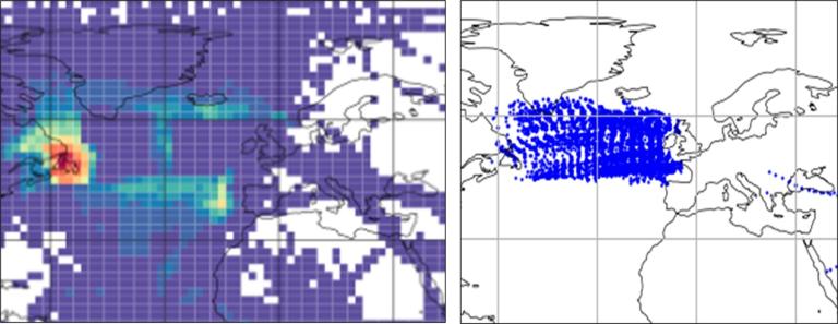
Figure 6-d: Left: ADS-C for one month; Right: AIREP for one day (mainly en route data)
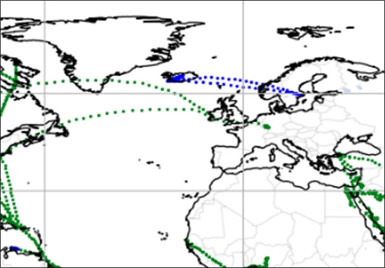
Figure 6-e: TAMDAR (blue), AFIRS AMDAR (green) for one day
The Met Office continues to work on a humidity project with Loganair to install FLHYT WVSS-II sensors on their Embraer 145 aircraft. This addition would deliver a significant increase in humidity profiles over the UK to support improvements in weather forecasting. DWD’s contrails project (MEFKON) is due to conclude in 2026 and the Met Office has been collecting additional en route humidity data at one-minute intervals (available on the GTS) from the nine Lufthansa aircraft equipped with the WVSS-II sensor. There continues to be significant interest in the climate impacts of contrails and the E-ABO programme manager is following the progress of the SESAR project, CICONIA, through their stakeholder outreach body.
As mentioned in Volume 26 of the WMO ABO newsletter, with increases in derived data from Mode-S EHS, the E-ABO programme is planning on a gradual reduction in AMDAR data over the next few years whilst maintaining a comprehensive ABO coverage. An impact study will be conducted during 2025/2026 to assess the effect of reducing AMDAR data over Europe where there is good coverage from Mode-S EHS derived wind and temperature data. It is expected that reductions in AMDAR will focus on a thinning of the en route data where a sufficient amount of Mode-S EHS derived data exists.
European ABO data continues to be affected by GPS interference (also known as GPS spoofing or jamming) which can lead to false locations and timestamps in AMDAR observations (Figure 6-f). Within the EUCOS area, GPS interference is occurring around the Baltic, Black Sea, Red Sea, Middle East and the far eastern sections of the Mediterranean. The E-ABO team is investigating options for improving quality control checks to prevent more of these erroneous data from being released to users.
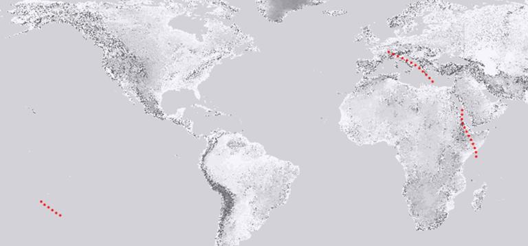
Figure 6-f: Example of false location information which is thought to be due to GPS spoofing. As the aircraft flying Africa to Europe encountered a GPS interference “hot spot” over the Red Sea, the location of the AMDAR data was “spoofed” to be over the South Pacific Ocean. The aircraft eventually corrected itself and data from the Mediterranean onwards behaved as normal.
During 2024, the EUMETNET ABO expert team met online in the spring and again in person at the Met Office in October where we discussed developments such as Mode-S EHS profiles, E-ABO coverage, turbulence data, UAS updates and contrail (and humidity) related projects.
Finally, the E-ABO programme manager continues to support the RTCA/EUROCAE joint working group 76 and its sub-groups on turbulence and ABO. These groups aim to develop a technical standard for turbulence reports and recommendations for more general ABO standards.
martyn [dot] sunter metoffice [dot] gov [dot] uk (Martyn Sunter), Met Office, E-ABO programme manager
Mr David Snook, Met Office, E-ABO technical co-ordinator
Aircraft-based Turbulence Observations Status within AMDAR
There are two accepted atmospheric turbulence intensity metrics currently used by the AMDAR community. The first metric is eddy/energy dissipation rate (EDR). MacCready (1964) first suggested the use of EDR as a measure of turbulence intensity. It is particularly useful operationally since EDR along the vertical direction is proportional to the RMS (root-mean-square) vertical acceleration experienced by an aircraft for any given flight condition (MacCready 1964; Cornman et al. 1995). Further, EDR has been adopted as the standard metric for atmospheric turbulence reporting by the International Civil Aviation Organization (2001).
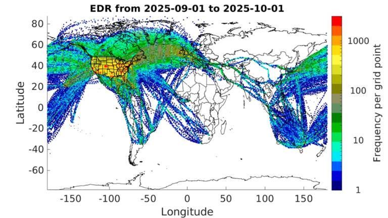
Figure 7a shows the locations of available EDR reports for September 2025. Currently, about 2,000 aircraft are reporting EDR worldwide with an average of over 115,000 observations per day. EDR reporting has increased globally but continues to be low across Africa, Asia and South America.
a)
b)
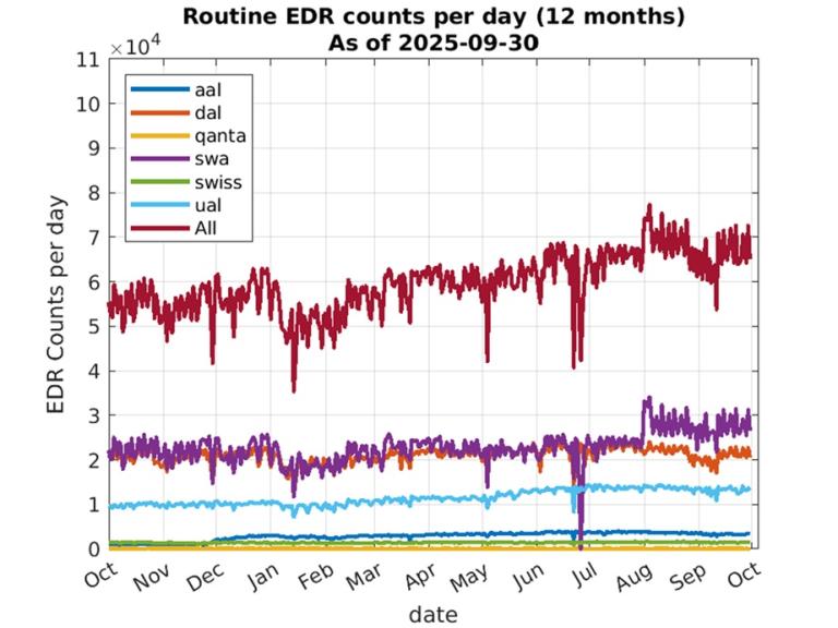
Figure 7. a) Counts of all available EDR reports for September 2025 using an approximately 50x50 km grid (the color scale is logarithmic); b) Counts of routine daily EDR observations by airline from October 1, 2024 to September 30, 2025.
Figure 7b shows the number of routine (non-turbulence event driven) observations per day from October 1, 2024 to September 30, 2025. We show the counts of routine observations rather than all observations since they are not impacted by the amount of elevated turbulence. A slight overall increase in routine observations is seen throughout the year. Note, that the days with much lower numbers of routine reports generally are those in which EDR data were not received for some period of time.
The second metric, derived equivalent vertical gust (DEVG), is defined as the instantaneous vertical gust velocity which, when superimposed on a steady horizontal wind, would produce the measured acceleration of the aircraft. The effect of a gust on an aircraft depends on its mass, aerodynamic characteristics as well as flight condition, but these factors are accounted for so that a gust velocity can be calculated which is independent of the airframe. As of May 2025, there were at least 150 aircraft reporting about 4,000 DEVG measurements per day. These numbers are based on an analysis of AMDAR data from The U.S. National Centers for Environmental Prediction’s Meteorological Assimilation Data Ingest System (MADIS). Figure 8 shows the locations of all DEVG reports for May 2025. There is software-based logic implemented on many aircraft that limit reporting of DEVG in some regions at certain altitudes (e.g., Europe). DEVG reporting had increased over North America but was still limited through Asia and the Southern Hemisphere. However, since mid-June 2025, DEVG data are, apparently, no longer included in the MADIS data. An investigation has begun to track down the reasons for this.
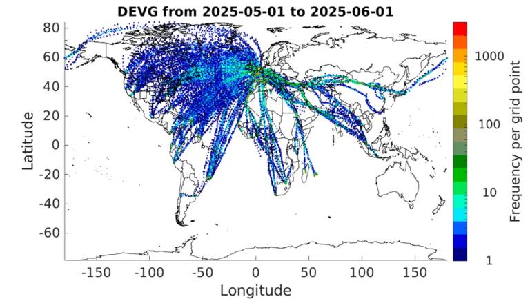
Figure 8: Counts of all available DEVG reports for May 2025 using an approximately 50x50 km grid.
These maps illustrate the need for expansion of aircraft-based turbulence observations in many areas of the globe. WMO continues to work withits Members and their respective national airlines to increase aircraft-based turbulence observation coverage.
WMO and its Members express gratitude to our aviation industry and airline partners for their continued contribution to the WMO Aircraft-based Observing System and the AMDAR program. The data produced from this collaboration are utilized within many meteorological applications and forecasts benefiting aviation operations and safety, other application areas and the wider general public.
For more information on aircraft-based observations data statistics visit the WMO website.
meymaris ucar [dot] edu (Gregory Meymaris), National Center for Atmospheric Research
ABOP Water Vapor Measurement Status
Overview of Water Vapour Measurement Programs Using WVSS-II and TAMDAR Sensors
Water vapour is a critical component in atmospheric processes and, therefore, is also critical to weather forecasting. Accurate measurement of airborne water vapour helps meteorologists understand humidity, cloud formation and precipitation patterns, thereby improving the reliability of weather predictions. Two prominent sensor technologies used in this capacity are the Water Vapour Sensing System II (WVSS-II) and the Tropospheric Airborne Meteorological Data Reporting (TAMDAR) which are both integral to water vapour monitoring programs.
WVSS-II Sensors: Stability Over Time
WVSS-II has been a reliable workhorse in atmospheric water vapour measurement. Over the last several years, programs utilizing WVSS-II sensors have remained largely stable with little change in the number of active sensors or data collection operations. This consistency highlights the durability and continued relevance of WVSS-II technology in ongoing meteorological efforts. Furthermore, new WVSS-II sensor installations currently are underway in the United States and the UK with the first installations expected by the end of 2025. This expansion reflects ongoing commitment to enhancing water vapour monitoring capabilities.

Table I: Operational WVSS-II units in service to ABOP by WMO Region
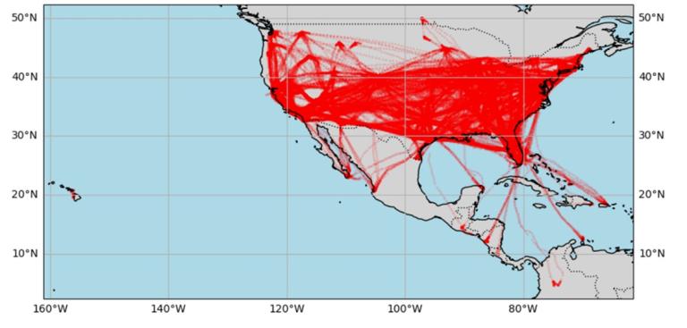
Figure 9: WVSS-II measurements from the North American AMDAR program from 06-12 October 2025 (source: NOAA)
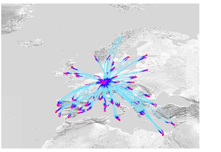
Figure 10: WVSS-II measurements over Europe from 05-11 October 2025, colours showing pressure altitude from red-lowest altitudes to turquoise-high altitudes (source: E-AMDAR portal, 16.10.2025)
TAMDAR Sensors: Decline Due to Fleet Retirements
In contrast, the TAMDAR sensor program has experienced a notable decline over the last few years. This reduction is attributed primarily to the retirement of aircraft fleets equipped with TAMDAR sensors which has led to a substantial decrease in data collected via this method. In the United States, the ABO program is working with the TAMDAR vendor to expand WVSS-II capability on their partner airlines. It is expected that over time, the growth of WVSS-II on their fleets will begin to offset the decline in TAMDAR which the vendor no longer manufactures.

Table II: Operational TAMDAR units in service to ABOP by WMO Region
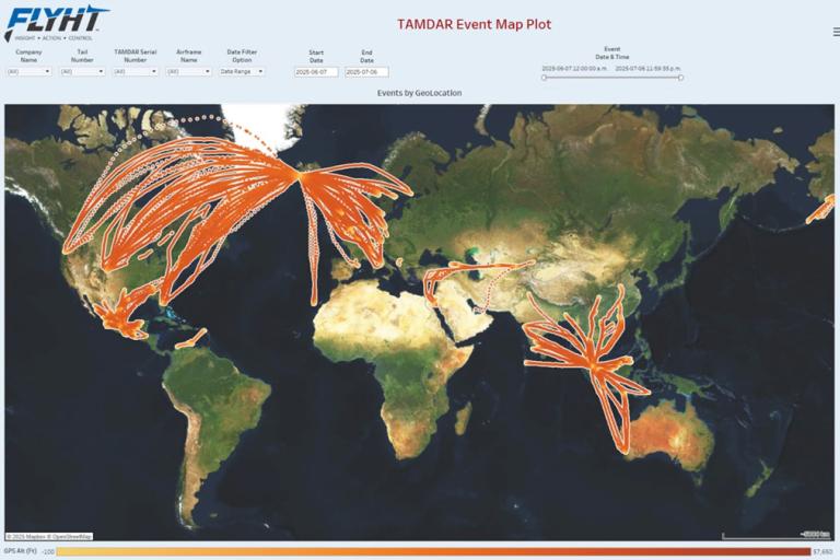
Figure 11: TAMDAR flight tracks for June 2025 (source: FLYHT)
Contrail Avoidance and the Need for Improved Water Vapour Sensors
During the past few years, contrail avoidance has become an area of increased interest within the aviation and atmospheric science communities. Several international studies emphasize that accurately measuring water vapour with improved sensor precision is essential for effectively predicting and mitigating contrail formation. Such advancements could reduce significantly the environmental impact of aviation-related cloud formation while at the same time, provide valuable data for general weather and aviation forecasting.
Geographical Gaps in Water Vapour Measurement
Currently outside of Europe and the continental United States, water vapour measurements by aircraft remain largely absent. This gap in observational coverage highlights a critical limitation in global atmospheric monitoring and underscores the need for expanded sensor deployment in under-sampled regions where the largest hurdle is the financial support.
carmen [dot] emmel dwd [dot] de (Carmen Emmel), Deutscher Wetterdienst (DWD), ABO Coordinator / SG-WVM Lead and ET-ABO Vice-chair
ABOP Aircraft Derived Data and Third-party Data Status
WMO ET-ABO SG-DTD (Sub-Group on Aircraft Derived and Third-party Data) Update
The Royal Netherlands Meteorological Institute (KNMI), through their European Meteorological Aircraft Derived Data Centre (EMADDC), is responsible for the operation and development of derived wind and temperature observations from Mode-S EHS data over Europe. The map below (Figure 12) provides an example of the derived data coverage for the European area from EMADDC for a single day. This interactive map can be viewed on the EMADDC website along with statistics on the number and quality of the observations collected. Figure 13 shows the number of observations processed each hour for 13 August 2025. It indicates that the quality-controlled data totals reach over two million per hour with tens of millions of wind and temperature observations available each day.
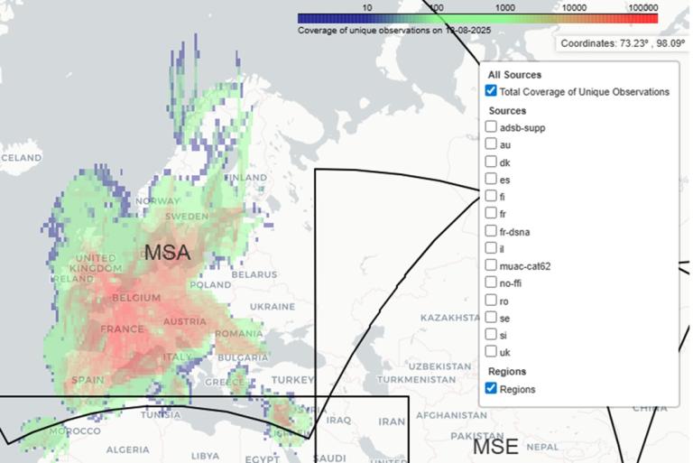
Figure 12: Number of derived data observations in 0.5°x0.5° grid box from Mode-S EHS for one day (EMADDC European coverage)

Figure 13: Number of Mode-S derived observations per hour for 13th August 2025.
Since September 2024, EMADDC have been processing the global Mode-S EHS derived data in partnership with the Met Office and these data are available for use by national meteorological services. The coverage for a typical day is shown in Figure 14 below.
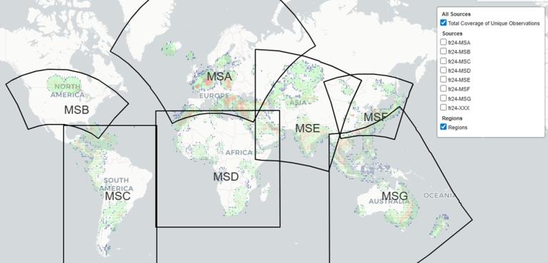
Figure 14: Coverage of the global Mode-S derived data set for one day
More national met services in Europe are assimilating Mode-S EHS derived wind and temperature data into global and regional NWP models. The global Mode-S EHS derived data are available to other national met services and the process to access the data can be found here: https://emaddc.com/participate/data+users/emaddc-met-office-global/default.aspx
The global Mode-S dataset has improved ABO coverage over data sparse areas of the world particularly over the tropics, Africa and Central and South America. These additional data have a significant impact on improving NWP. See the ECMWF newsletter for an example.
EMADDC is developing a new processing system (EMADDC 3.0) designed to enable near real-time processing of both global and European data within a unified platform thereby creating operational synergies. This upgrade will reduce significantly the latency of processed observations compared to previous methods. Additionally, this system will be more robust and support real-time data ingestion. EMADDC is collaborating with all its partners to facilitate a transition toward real-time data delivery while moving away from batch processing methods. The new system will be available for testing in Q4/2025 or 2026. Mode-S EHS derived winds and temperatures can be used to plot vertical profiles which will benefit operational meteorologists.
ABO continues to be available from other sources such as ADS-C (Figure 15), AIREP (Figure 16), AFIRS, AMDAR and TAMDAR (Figure 6). However, we don’t receive ADS-C data from some FIR regions particularly over the Pacific and the southwest North Atlantic. Collecting ADS-C weather reports from these regions would help fill large data gaps globally and help improve forecast accuracy.
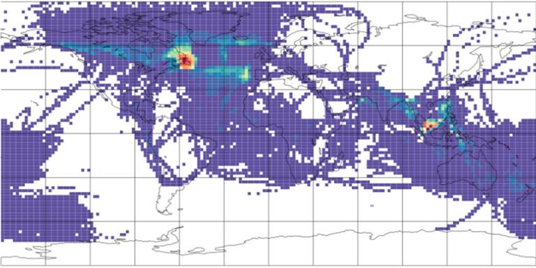
Figure 15: ADS-C coverage for seven weeks of data – data mainly at cruise level. Source: ECMWF website
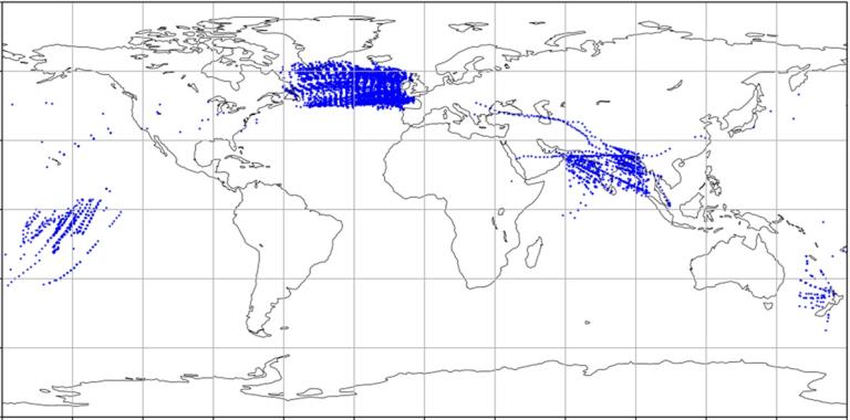
Figure 16: AIREPs coverage for one day. Source: Met Office
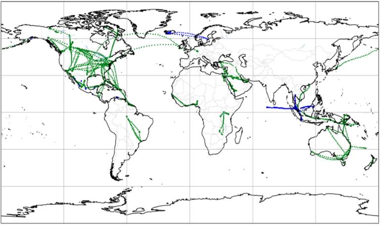
Figure 17: AFIRS (green) and TAMDAR (blue) for one day. Source: Met Office
Finally, ADS-B version 3 provides the option for aircraft to broadcast weather data in their routine ADS-B messages. Friends and Partners in Aviation Weather (FPAW) has written a position paper on the benefits of ADS-B weather and recommends its adoption by the aviation industry.
This also is addressed in the 42nd session of the International Civil Aviation Organization (ICAO) Assembly Working Paper A42-WP/215 ‘Increasing Aviation Resilience to Hazardous Meteorological Events’ where the Assembly is invited to ‘request ICAO to encourage States, organizations (e.g., IATA), and industry to share meteorological information from aircraft such as routine aircraft observations and reports, for free, especially those containing quantitative turbulence information and leveraging modern technologies, such as ADS-B version 3.0 to enhance atmospheric modelling, forecasting and nowcasting, and support a further improvement in the safety of all airspace users.’
martyn [dot] sunter metoffice [dot] gov [dot] uk (Martyn Sunter), Met Office, E-ABO programme manager, ET-ABO SG-DTD Lead
Paul de Jong, EMADDC Scientist KNMI
Jan Sondij, Programme Manager EMADDC, KNMI
The Kenyan AMDAR Programme
The Kenya AMDAR (K-AMDAR) programme is a pioneering public-private partnership between the Kenya Meteorological Department (KMD), Kenya Airways and the World Meteorological Organization (WMO).
Launched under the WMO-African Ministerial Conference on Meteorology (AMCOMET) and supported by the United Kingdom Department for International Development - Weather and Climate Information for Africa (UK DFID-WISER) Programme in 2017, the initiative was designed to strengthen meteorological services across key sectors — aviation, agriculture, health, environment, disaster risk reduction and economic planning.
Originally planned for three years, the project was extended to March 2021 due to implementation challenges. After South Africa, Kenya became the second country in Africa (RA-I) to operationalize AMDAR.
Today, the programme continues to expand with WMO’s support. Currently, four Kenya Airways B737 aircraft are operational with three more expected by year’s-end. Data coverage has grown significantly with a sharp rise in observations between 2024 and 2025 as shown below. Nairobi airport had averaged around 10 profiles per week but now averaging over 50 soundings weekly.
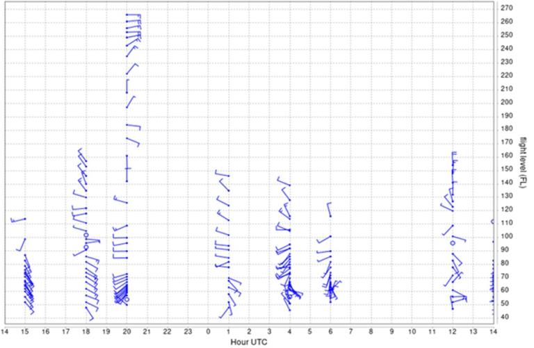
Figure 18: One day observations at Nairobi Airport (NBO) on 02/10/2025
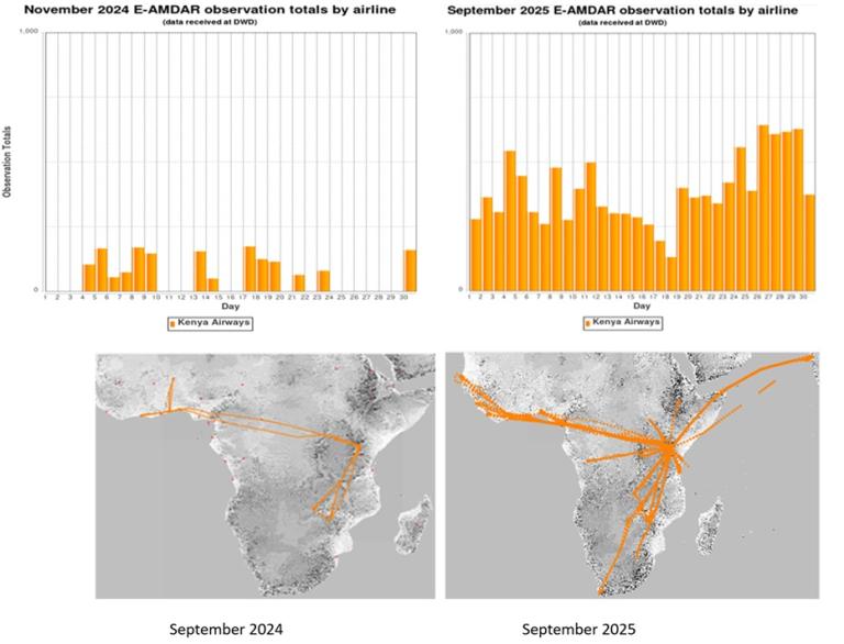
Figure 19: Coverage of K-AMDAR Programme September 2024 vs September 2025.
Benefits of K-AMDAR Data
For NMHS (National Meteorological and Hydrological Services)
• Verification and updating of forecast products
• Trial phase of data assimilation into NWP models
• Development of new forecast products
• Improved nowcasting and short-range forecasting
• Detection of atmospheric instability and inversions
• Overall improvement in local weather forecasts
For Aviation (KMD is the designated ICAO meteorological authority in Kenya)
• Safer and more efficient flight operations
• Fuel efficiency and reduced operational costs
- Optimized airline routing and flight planning
• Monitoring of low-level wind shear with timely turbulence warnings
• Accurate fog forecasts improving air traffic management
• More precise terminal aerodrome forecasts (TAFs)
• Reduced delays — addressing weather as a major source of airport disruptions (fog, haze, etc.)
Conclusion
The K-AMDAR Programme is proving to be a game-changer for Kenya and the wider Region I through:
• Enhanced Forecasting: Better detection of severe weather, instability and inversions
• Operational Gains: Safer routing, accurate TAFs and optimized flight planning
• Efficiency & Cost Savings: Reduced fuel use and improved airline management
• Air Traffic Management: Improved traffic flow, fewer delays and safer skies
Future Outlook: Transitioning from trial to full NWP data assimilation will unlock new forecast products and targeted warnings.
As the programme grows, aviation stakeholders, including aircraft manufacturers and system providers, are encouraged to help lower the cost of AMDAR onboard software and supplemental type certificates ensuring broader adoption and sustainability.
anguluhg meteo [dot] co [dot] ke (Humphrey Angulu), Programme Manager Kenya AMDAR
The 2024 WMO UAS Demonstration Campaign
The main goal of the 2024 WMO Global Uncrewed Aircraft Systems (UAS) Demonstration Campaign (DC) was to evaluate and advance the operational readiness of weather-sensing UAS (WxUAS). The WMO UAS DC took place from 1 March through 30 Sept 2024. WxUAS craft were flown at more than 50 different locations in 13 countries around the world with regional concentrations in the U.S. and Europe (Figure 20). An assortment of different light-weight WxUAS participated in the UAS DC including multirotor, fixed-wing and vertical take-off and landing (vTOL) UAS as well as a long-distance ballasted balloon system.
The WxUAS measured temperature, pressure, relative humidity and winds by performing vertical profiling or horizontal transects. Some WxUAS also collected high-rate, three-component wind data that can be used to determine turbulence intensity. Over 13,000 UAS data files have been obtained with maximum attained altitudes ranging from 120m to 6000m above mean sea level (MSL) with data from over 80% of the flights being uploaded within one hour of the data collection time (Figure 21). Observation files were uploaded into the Amazon Web Service S3 data repository, converted to BUFR and made available to subscribers (e.g., NWP modeling centers) via the WMO Information System (WIS2.0) using infrastructure and software developed by the European Centre for Medium-Range Weather Forecasts and Synoptic, a Public Benefit Corporation. Some files have been updated within the last six months to correct data or file format issues. So, it is important to obtain the latest files when using the data. Plans currently are being developed to create a longer-term data archive.
Recent activities have focused on comparing WxUAS observations to NWP background data to assess background error statistics. A preliminary study by Alexander Cress at Deutscher Wetterdienst found that the spread of WxUAS observations minus model background (O minus B) where the background (otherwise known as first guess field) was obtained from the Consortium for Small Scale Modelling (COSMO) model for temperature, relative humidity and winds were 0.5 K-1.0 K, 5%-10% and 1.0m/s-2.0m/s, respectively. These values are of the same order as those typically found for commercial aircraft observations. A similar analysis was conducted using raw WxUAS data collected during the International Society for Atmospheric Research using Remotely-piloted Aircraft (ISARRA) Small-UAS Coordination for Atmospheric Low-level Environmental Sampling (SCALES) Flight Week. These WxUAS observations were compared with analyses from the NCEP/NOAA High-Resolution Rapid Refresh (HRRR) model. Spreads of temperature, relative humidity and winds were similar to those reported in the COSMO comparisons with values of 1.2 K, 6% and 2m/s, respectively. Closer inspection reveals positive (negative) skewness in the distribution of errors found for temperature (winds) (Figure 22). The impact of intercalibration was largest on temperature in which the process changed the sign of the model bias.
The WMO UAS DC was highly successful in advancing WxUAS toward operational implementation. Key follow-on activities include the assessment of WxUAS observations on model skill via observing system experiments (OSEs) and continued work using observing system simulation experiments (OSSEs) to optimize WxUAS sensing strategies in terms of network spacings, profiling frequencies and depth and also to improve the parameters required by variational and ensemble-based data assimilation systems. There also must be some effort to obtain feedback from data users to refine the data formats and to make documentation more user-friendly for operators to properly implement. Work should proceed to establish permanent infrastructure to facilitate the dissemination of WxUAS observations. Finally, the WMO and NHMSs should continue to work with civil aviation authorities to increase access to airspace to allow for more routine profiling of the lower 1km to 2km of the atmosphere. A full report of the WMO UAS DC outcomes and recommendations will be published early in 2026.

Figure 20: Locations of UAS observation locations not including the locations covered by ballasted balloon system.

Figure 21: (left) Distribution of maximum vertical height attained by WxUAS during each flight in 250 m bins. (right) Distribution of file upload latencies determined from the difference between the file timestamp and the time file was uploaded into the AWS S3 bucket

Figure 22: Error distributions obtained via comparisons of WxUAS observations and HRRR analyses for the period 9-13 September 2024 for (left) temperature, (middle) relative humidity and (right) wind speed. Comparisons were made using HRRR hybrid level data below 850 hPA and WxUAS observation within 15 min of the HRRR analysis time. Blue bars computed before inter-WxUAS calibration and orange colors after inter-WxUAS calibration
pinto ucar [dot] edu (James Pinto), Senior Scientist & Deputy Director, Transportation Meteorology Applications Program, NSF National Center for Atmospheric Research
Assimilation of Global Mode-S Data Brings Major Forecast Benefits
Thanks to a Met Office contract with FlightRadar24 and processing by the European Meteorological Aircraft Derived Data Center (EMADDC, part of the Royal Netherlands Meteorological Institute [KNMI]), global Mode-S data became available in October 2024. This data set is in addition to a European Mode-S product which has been available from EMADDC since 2020. Global Mode-S data are accessible from the KNMI data platform via an application programming interface (API) to other national meteorological services that have a signed a data licence with the Met Office.
(see https://emaddccom/participate/data+users/emaddc-met-office-global/default.aspx)
Figure 23 shows the Mode-S upper-level coverage for July 2025 for the combined European and global datasets. The coverage depends on aircraft being interrogated by air traffic control systems which occurs in some regions but not others.
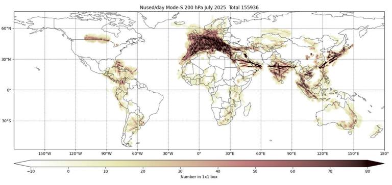
Figure 23: Number of Mode-S daily reports used at ECMWF in July 2025 in 1°x1° boxes, 200+/-25 hPa. Lower tropospheric coverage is less extensive and only available near airports.
At the European Centre for Medium-Range Weather Forecasts (ECMWF), several trials were run from 15th October 2024 to 31st January 2025. The results were very encouraging and it was decided to assimilate the global Mode-S winds operationally together with an aircraft thinning change at ECMWF as of 8th May 2025. The Met Office and Météo-France are expected to start using the data operationally in 2026. Especially over parts of Europe, the density of Mode-S reports can be very high and NWP centres have found it necessary to modify their aircraft thinning process or take other measures to avoid computational problems. At both the Met Office and ECMWF, this has included an additional pre-thinning step. ECMWF is assimilating only the winds operationally, though the Met Office intends to use the temperatures as well, despite the additional effect of the temperatures being small. The impact of the extra winds is large especially at low latitudes (including southern Asia). Wind information is particularly important in the tropics but unfortunately is scarce there.
Figure 24 shows the effect of the use of global Mode-S winds plus the thinning change on the 12-hour forecast fit to AMDAR aircraft winds. The effect measured against radiosondes and satellite data shows similar patterns. At short-range, the largest improvement (up to about 8%) is in the tropical winds with southern mid-latitudes also showing large gains. In the medium range, there are significant improvements to mid-latitude forecasts measured against both observations and analyses. The number of aircraft winds utilized daily in the trial increased from 691K to 1695K. This huge upturn in reports also gives a major benefit to short- and medium-range weather forecasts. Similar results also were seen in the Met Office tests.
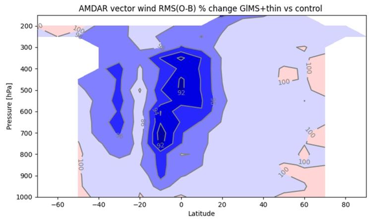
Figure 24: Changes in the background (T+12) vector wind RMS fit to AMDAR (contours at 2% intervals) calculated for 10° latitude bands and 50 hPa vertical intervals, 15 Oct 2024 to 31 Jan 2025 (ECMWF test).
Like ECMWF trials, Met Office results also were highly promising. These trials ran between 1st March 2024 and 31st May 2024 and assimilated both global and European Mode-S data together for comparison against a control run which assimilated no Mode-S and a second trial just including European Mode-S reports. The additional assimilation of global Mode-S improved scores globally and provided valuable forecast skill in areas that historically had been less observationally dense. Root Mean Square Errors (RMSE) calculated against observations decreased most notably for wind, air temperature and geopotential height forecasts out to T+48 in many regions, though up to T+144 in the Northern Hemisphere (NH). Similar RMSE improvements were found when evaluating forecasts against analyses generated from later cycles and ECMWF analyses. Figure 25 is an example of this forecast improvement and shows the average changes in RMSE differences in NH T+12 background fit when evaluated against radiosondes. In the NH, the additional reduction in RMSE differences from assimilating derived global Mode-S observations was greater than the benefit from assimilating European Mode-S observations alone. Assimilating global Mode-S data also provided more upwind information which extended the benefits further into the forecast. Similar RMSE improvements were found when evaluating forecasts against analyses generated from later cycles and ECMWF analysis.
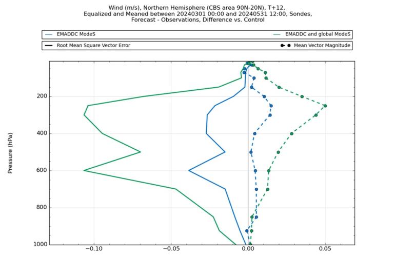
Figure 25: Differences in the Northern Hemisphere background (T+12) vector wind root mean square vector difference (solid) and mean speed difference (dot dashed) fit to radiosondes between a control with no Mode-S. Two trials were conducted - Trial 1 with European Mode-S (blue) and a trial 2 with European and global Mode-S (green). Study period 01 March 2024 to 31 May 2024. Note: Mode-S wind and temperature observations were assimilated.
Further reading:
- de Haan et al (2025): EMADDC: High-Volume, High-Quality, and Timely Wind and Temperature Observations from Aircraft Surveillance Data (Mode-S EHS), https://doi.org/10.5194/amt-18-3341-2025
- Ingleby (2025): The Benefits and Challenges of Using Dense Mode-S Aircraft Winds at ECMWF, Quarterly Journal of the Royal Meteorological Society, http://doi.org/10.1002/qj.70032
- Warren et al (2025): Assimilation of European and Global Mode-S Observations into the Met Office Global Deterministic NWP Model (QJRMS, under review)
Bruce [dot] Ingleby ecmwf [dot] int (Bruce Ingleby), European Centre for Medium-Range Weather Forecasts
Elliott Warren, Met Office
The Benefits of Reporting and Using GNSS Altitude from Aircraft
Automated meteorological reporting from aircraft (the forerunner of AMDAR) began in 1979. Then the only available vertical coordinate was pressure which was provided via flight level. Use of GPS by commercial aircraft began in about 1994. Measurement of static pressure by a rapidly moving aircraft is difficult because the airframe itself disturbs the pressure field.
WMO No 8 (volume III, chapter 3; see https://community.wmo.int/en/guide-instruments-and-methods-observation-wmo-no-8) suggests that, at best, the aircraft pressure uncertainty is of the order of 1 hPa, but, for various reasons, it can be much greater partly because of rounding of the flight levels. In contrast, pressure uncertainty from a radiosonde can be 0.2 hPa (although many Global Navigation Satellite System [GNSS] radiosondes do not have a pressure sensor). Typical vertical accuracy of GNSS measurements is now about 5 meters (corresponding to pressure accuracy of about 0.34/0.16 hPa at 500/200 hPa respectively). Currently, if one were developing aircraft meteorological reporting from scratch, the natural vertical coordinate to use would be the GPS/GNSS altitude. Some work would be needed to change the vertical coordinate in aircraft ‘observation operators’ used in modern NWP systems, but this is quite feasible.
The AMDAR format has an available column for GNSS altitude, unfortunately it is generally unused. For years some British Airways (BAW) aircraft, those in the A320 family, have reported GNSS altitude. These were joined in 2024 by KLM Royal Dutch Airlines B777 long-haul aircraft. Also in 2024, some WindBorne reports became available on the GTS. These are long-duration, balloon-borne systems which, because of their duration and level flight at times, are aircraft-like in some respects. The ECMWF processing systems have been modified to convert GNSS altitude to geopotential height and observation-minus-background (O-B) statistics are now available. The background is a 12-hour forecast from the time of the observation.
Figure 26 shows statistics for a period of three summer months (June – August 2025). The numbers clearly are best for the WindBorne data (red). Between 900 and 250 hPa, the standard deviation (SD[O-B]) is about 6 geopotential meters (gpm). The ECMWF background is not perfect, but these results provide some confidence when using it as a reference for the AMDAR reports. The AMDAR SD(O-B) statistics are worse probably because of the larger errors in aircraft pressures – the GNSS altitude errors should be similar. Mid-tropospheric SD(O-B) is about 18 gpm for BAW and 11 gpm for KLM. BAW uses older AMDAR software with more rounding of the flight level (to 100 ft). (The mean differences, not shown, are much worse for AMDAR than WindBorne, again, presumably caused by pressure errors.) Figure 27 shows the geographical distribution of SD(O-B) at about 250 hPa. It is thought that some of the larger differences over the north Atlantic and USA (USA is subject to severe convection) mainly reflect larger model errors – which potentially could be corrected using data assimilation.

Figure 26: Standard deviation of height (gpm) differences as a function of pressure, 50 hPa bins, June-August 2025 (differences over 70 gpm were excluded from the statistics).
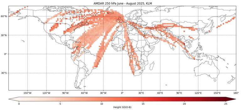
Figure 27: Standard deviation of height differences for KLM aircraft between 225 and 275 hPa.
In summary, we suggest that GNSS altitude would provide a better vertical coordinate for the assimilation of aircraft wind and temperature observations. In some areas, assimilation of aircraft pressure as a function of height should provide extra information, but development and testing is needed before this can be determined. A prerequisite for the developments outlined here is that many more AMDAR reports should provide GNSS altitude.
Bruce [dot] Ingleby ecmwf [dot] int (Bruce Ingleby),European Centre for Medium-Range Weather Forecasts (ECMWF)
Closing Thoughts: Back to Normal, Slowly…
With the COVID-19 pandemic thankfully well behind us, it is promising to see the ABO system making a steady although uneven recovery. The good news is that the latest (October 2025) reports show conventional ABO data across Europe, U.S. and the Southwest Pacific are now back to and in some cases exceeding pre-pandemic levels. The bad news, several of the world’s programs are lagging behind in their recovery efforts. Data details can be found in the ABO status update in this newsletter edition.
This upturn in observations grew from the lowest data numbers in March of 2020 (during the height of the pandemic) of roughly 245k observations per day on average to a current daily average of almost 850k reports which is on par with data levels before COVID-19.
Over the past few years, turbulence monitoring has realized unprecedented success. Prior to the pandemic, daily turbulence reports averaged, as of January 2020, just over 91,000 (about 74,000 eddy dissipation rate [EDR] reports and a little more than 17,000 derived equivalent vertical gust [DEVG] observations). At the height of COVID-19 (May 2020), average turbulence observations dipped to a little more than 36,000 (30,000 EDR and just over 6000 DEVG) per day. Post-pandemic turbulence reporting has come roaring back surpassing pre-COVID-19 levels. As of May 2025, daily totals have averaged nearly 124,000 (just about 120,000 EDR and 4000 DEVG).
It is the hope of the entire ABO community that in those areas where programs are struggling to recover, strides will be made as airlines and NMHSs try to restart their collaborative efforts. It is encouraging to note that in RA-III talks currently are underway with LATAM Airlines to potentially gain the airline’s participation.
In RA-I, similar efforts are ongoing between Maroc Météo, Royal Air Maroc and EUMETNET to revive the Moroccan AMDAR program.
While these activities show promise, there is still much work to do. ET-ABO will provide support where and when it can to help these and other struggling ABO programs get back on their feet.
ceweiss1949 gmail [dot] com (Carl Weiss), WMO ABO Newsletter Editor
Contacts
WMO Commission for Observation, Infrastructure, and Information Systems -INFCOM- / Standing Committee on Earth Observing Systems and Monitoring Networks (SC-ON)/
Expert Team on Aircraft-Based Observing Systems (ET-ABO) 2024-2027
Chair
curtis [dot] marshall noaa [dot] gov (Mr Curtis Marshall) (USA)
Vice-chairs
carmen [dot] emmel dwd [dot] de (Ms Carmen Emmel) (Germany)
anguluhg gmail [dot] com (Mr Humphrey Angulu) (Kenya)
WMO ABO Observing System Newsletter Editor
ceweiss1949 gmail [dot] com (Mr Carl Weiss) (USA)
WMO Secretariat, Aircraft-based Observations
nrivaben wmo [dot] int (Mr Nicolás Rivaben)
Subscription & Links
- Newsletter email subscription - complete form & subscribe to: wmo-aircraft-observations-news
- WMO Aircraft-Based Observations
- WMO AMDAR Observing System
- Newsletters
