


WMO Uncrewed Aircraft Systems Demonstration Campaign (UAS-DC)
1 March – 31 October 2024 | Completed campaign
| This campaign has ended. The UAS-DC observing period ran from 1 March to 31 October 2024. This page is an archive of the campaign: it summarizes what was done and what was learned, and links to the final report and related documents. Calls for participation, registration forms and data-repository access requests are closed. |
The WMO Uncrewed Aircraft Systems Demonstration Campaign (UAS-DC) was the first globally coordinated campaign to test whether weather-sensing uncrewed aircraft systems (WxUAS, or drones) can contribute routinely to the WMO Integrated Global Observing System (WIGOS). Coordinated by the WMO Commission for Observation, Infrastructure and Information Systems (INFCOM), it brought together UAS operators and data users from the public, academic and private sectors to collect and share near-real-time observations of the lower atmosphere, where the observational gap in the global observing system is largest.
Key facts of the campaign
| Observing period | 1 March – 31 October 2024 (8 months) |
| Special Observing Periods | April 2024 – total solar eclipse of 8 April 28 July – 14 August 2024 – Paris 2024 Olympic Games 8–13 September 2024 – ISARRA flight week and SCALES campaign, Oklahoma, USA |
| Participation | 44 UAS operators from 13 countries (national meteorological and hydrological services, research institutions and companies), plus data users including ECMWF, DWD, MeteoSwiss and NOAA GSL |
| Observations | More than 13,000 flights and 13,100 standardized data files |
| Platforms | Multirotor (about 82 % of logged flights), fixed-wing (10 %), VTOL (2 %), balloon-released dropsondes (5 %), balloon-launched gliders and long-duration balloons |
| Altitude range | Mostly the lowest 1.5 km of the atmosphere; UAS up to 9,000 m and balloon platforms up to 23,000 m above mean sea level |
| Data exchange | WMO-CF UAS Trajectory (NetCDF) format, automatic conversion to BUFR, distribution through WIS 2.0; more than 80 % of files available within one hour |
| Coordination | WMO INFCOM, through its expert team on aircraft-based observations and the UAS-DC Scoping, Planning and Organizing Committee (SPOC) |
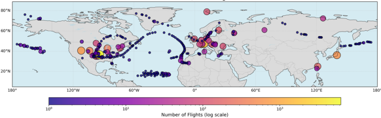
Figure 1. Locations and number of flights uploaded to the central repository during the UAS-DC (March–October 2024).
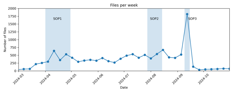
Figure 2. Number of data files uploaded per week. Shaded bands show the three Special Observing Periods.
INFCOM-1 Decision
Following the WMO Workshop on the Use of Unmanned Aerial Vehicles for Operational Meteorology (Toulouse, July 2019), Decision 18 (INFCOM-1), adopted in April 2021, endorsed the development of a WMO-coordinated global demonstration project. The campaign plan was prepared by the SPOC, endorsed by the INFCOM Management Group in 2022 and presented to INFCOM-2. The campaign theme was:
“WMO will coordinate a global demonstration project on the utility and efficacy of Uncrewed Aircraft Systems (UAS) to routinely and operationally contribute to the WIGOS Global Basic Observing Network (GBON).”
Aims
- Demonstrate the capabilities of a range of UAS and measure their capacity to meet operational requirements for upper-air observations and to fill observational gaps in GBON and the Regional Basic Observing Networks (RBON).
- Demonstrate that UAS and their data processing systems can provide data in an interoperable format, ready for use by applications and forecast systems.
- Measure, analyse and report on the impact of UAS observations on WMO application areas and forecast systems.
- Identify the developments needed for UAS to contribute to WIGOS operationally, efficiently, economically and in an environmentally responsible way.
- Make recommendations on the regulatory conditions that affect the ability of UAS to contribute to WIGOS.
Coordination activities
The campaign (2022–2024) was organized under WMO INFCOM and coordinated by JET-ABO, and later ET-ABO (after INFCOM III), together with the SPOC and a UAS Core Coordination Group. The SPOC prepared the campaign plan, which the INFCOM Management Group endorsed in 2022. It also defined participant requirements and held regular online meetings with participants. Operators submitted their observations in a standard format to a central repository run by Synoptic Data. There the data were converted from NetCDF to BUFR and distributed through WIS 2.0 to data users for analysis, assimilation and NWP impact studies. Post-campaign reports from operators and data users fed into the final report and its recommendations.
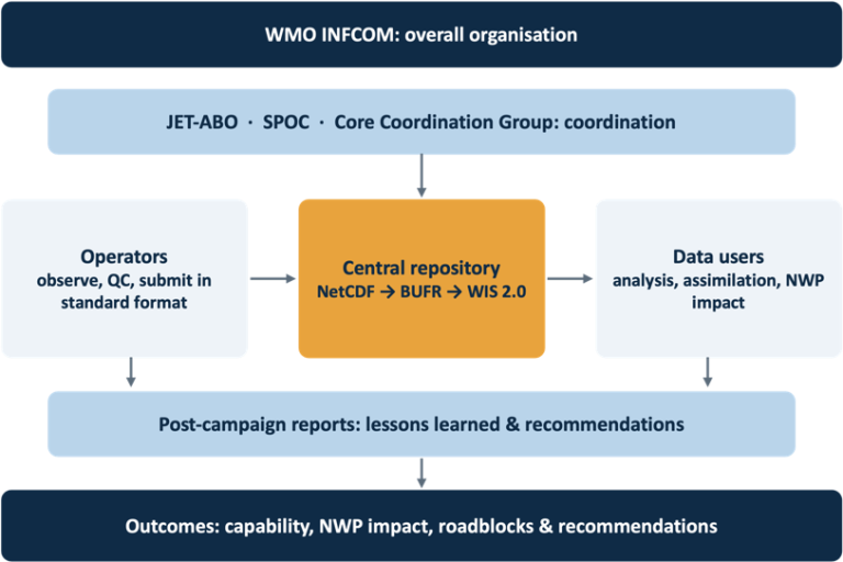
Figure 3. Organisation of WMO UAS DC activities.
Participants
- UAS operators volunteered to fly routinely – at least once a day on four or more days per week – for at least one month and, if possible, during a Special Observing Period, and to deliver their data in near-real time (preferably within 30 minutes, at most 3 hours).
- Data users – mainly NWP centres, meteorological services and research organizations – used the data in their systems and assessed their quality and impact.
- All participants took part at their own cost and agreed to the UAS-DC Data Policy.
Special Observing Periods (SOPs)
- SOP 1: Total solar eclipse (April 2024). Operators across North America sampled the rapid cooling, stabilization and moistening of the boundary layer during the eclipse of 8 April, showing the value of WxUAS for targeted observations of fast-changing conditions.
- SOP 2: Paris 2024 Olympic Games (28 July – 14 August 2024). European operators increased their flights in support of high-resolution forecasting, alongside the WMO Research Demonstration Project for the Paris 2024 Games.
- SOP 3: ISARRA flight week and SCALES (8–13 September 2024). In Oklahoma, USA, about 30 platforms completed more than 1,000 flights in one week, including coordinated multi-platform deployments at mesonet sites and in urban areas.
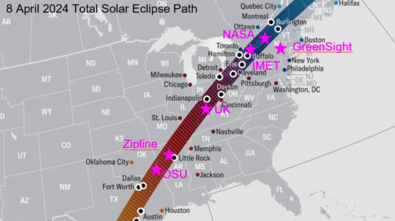
Figure 4. Path of the total solar eclipse of 8 April 2024 and locations of UAS-DC operators (courtesy of James Pinto).
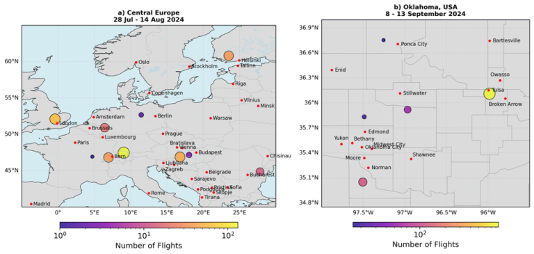
Figure 5. Flight locations during SOP 2 in Europe (28 July–14 August 2024) and SOP 3 in Oklahoma, USA (8–13 September 2024).
Data exchange
Operators uploaded each flight as a NetCDF file in the WMO-CF UAS Trajectory format to a central repository operated on behalf of WMO by Synoptic Data PBC. Files were converted automatically to BUFR and distributed to registered data users through the WMO Information System (WIS 2.0). Conversion scripts and templates are available on the campaign GitHub repository (github.com/synoptic/wmo-uasdc).
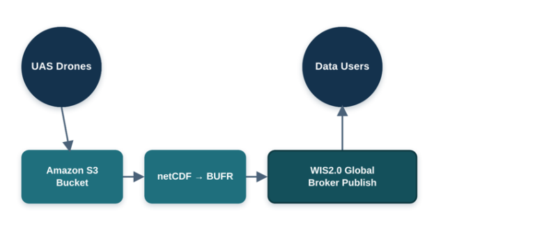
Figure 6. UAS-DC data pipeline: from the operators' NetCDF files to BUFR and distribution to data users through WIS 2.0.
Data policy
The UAS-DC Data Policy (February 2024) allowed participants to use the data in meteorological and hydrological applications within the scope of the campaign, and their use in the campaign reports. Data were not made available to third parties outside the group of participants without the agreement of the operator that provided them, and participants did not compare their systems with those of other participants unless mutually agreed. The data may be kept in the WMO archive without time limitation.
Key results
- A global first. The UAS-DC was the first globally coordinated WxUAS observing exercise, showing that a public–private network of this scale can be organized and operated.
- Interoperable, near-real-time data. A common data format and an automated pipeline into WIS 2.0 were adopted by a very diverse fleet, with most data available to forecasters and modelling centres within one hour. The analysis of the distributed data also revealed duplicate files, coexisting processing versions of the same flights and insufficient metadata on sensors and processing, which need to be addressed before operational use.
- Reliable operations. Technical problems affected fewer than 2 % of flights (excluding weather), and about half of the operators reported no significant technical issues.
- Data quality. For the best-characterised systems, published validations and comparisons of co-located flights indicate boundary-layer accuracy comparable to ground-based remote sensing: temperature at the goal-to-breakthrough level, humidity at the threshold level and wind at the breakthrough-to-threshold level of the WMO OSCAR requirements for high-resolution NWP in the boundary layer. Other systems reached only the threshold level for temperature, or did not meet it in daytime because of take-off effects or solar heating of insufficiently shielded sensors, and no system reached the goal level for humidity or wind. A systematic validation of all systems against reference instruments remains to be done.
- Suitable for data assimilation. Comparisons with NWP background fields showed few outliers, although such comparisons include model errors and cannot on their own demonstrate compliance with the OSCAR requirements. Platform-dependent biases were not flagged in the distributed data. Severeal Observing system experiments (OSEs) demonstrated the value of this dataset for NWP. (see Final Report)
- Weather limits. Weather affected about 12 % of logged operations, mainly strong winds, precipitation, icing and low visibility; small multirotors were usually limited to winds of 12–15 m/s.
- Regulation is the main barrier. Lengthy approval processes for flights beyond visual line of sight (BVLOS) and above 120 m, and the requirement for a pilot and an observer per aircraft, were the main obstacles to routine operations.
- New concepts tested. Coordinated drone swarms and balloon-launched gliders were used operationally for the first time.
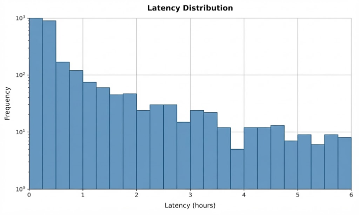
Figure 7. Time between observation and upload of the data files: more than 80 % were available within one hour (courtesy of James Pinto, WMO ABO Newsletter Vol. 27).
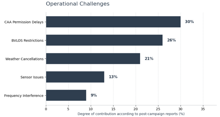
Figure 8. Main operational challenges reported by operators in the post-campaign reports.
Recommendations raised in the campaign
| For | Main recommendations |
|---|---|
| UAS operators | Multi-level calibration (laboratory, wind tunnel, in-flight comparison with reference instruments); use of the WMO-CF UAS Trajectory format with extended metadata on sensors, platform and processing; processing-version identifiers in every file and withdrawal of superseded versions and duplicate uploads from WIS 2.0; correction or flagging of known effects (take-off transients, solar heating, humidity sensor response time); participation in intercomparisons, with day and night cases; robust safety and risk-mitigation measures to support airspace approvals. |
| Regulators (ICAO, civil aviation authorities, air navigation service providers) | Streamlined, risk-based approval pathways for routine meteorological profiling; practical BVLOS procedures; dedicated or simplified airspace access; integration of WxUAS into UTM/U-space; recognition of the public-benefit nature of weather observations in risk assessments. |
| NMHSs | Identify priority gaps and applications; choose an operating model (own operations or data-as-a-service); adopt standard data formats and WIS 2.0 exchange; use testbeds and impact studies to plan networks; build the necessary capacity. |
After the campaign
The campaign results feed into the work of the INFCOM Expert Team on Aircraft-Based Observing Systems (ET-ABO), including:
- updating the guidance on WxUAS in the Guide to Aircraft-based Observations (WMO-No. 1200) and related WIGOS material (including WMO No. 1160 and GIMO Guide);
- including the UAS data format in the Manual on Codes (WMO-No. 306);
- integrating weather-sensing UAS as a component of the future WMO Aircraft-based Observations Programme, together with pilot projects in data-sparse regions.
A dedicated WMO intercomparison of WxUAS against reference instruments is recommended as the next step to establish their capacity to meet OSCAR Surface requirements,.
Reports and documents
| Document | Author | Date |
|---|---|---|
| Final Report of the WMO UAS Demonstration Campaign [link] | SPOC members, campaign participants and the UAS-DC Editor | Version 1.3 (draft), 2026 [update when published] |
| Preliminary report [link] | WMO | [insert date] |
| UAS-DC Data Policy [link] | WMO | February 2024 |
| Plan for the WMO UAS Demonstration Campaign, Version 1.2 (INFCOM-2/INF. 2(3)) [link] | UAS-DC SPOC | September 2022 |
| White paper: Global demonstration campaign for evaluating the use of UAS in operational meteorology [link] | O’Sullivan, Pinto and Lockett | August 2023 |
| UAS-DC flyer [link] | WMO | April 2022 |
| Decision 18 (INFCOM-1): Plan for a global demonstration project on the use of UAS in operational meteorology [link] | INFCOM | April 2021 |
| Workshop on Use of Unmanned Aerial Vehicles (UAV) for Operational Meteorology – final report [link] | WMO | July 2019 |
Selected scientific publications
WMO UAS DC publications list is available here: WMO_UAS-DC_publications.
Related UAS campaigns
| Year | Campaign | Location | Website |
|---|---|---|---|
| 2018 | LAPSE-RATE | San Luis Valley, Colorado, USA | zenodo.org/communities/lapse-rate |
| 2020– | NOAA ARL/ATDD UAS testbed | Tennessee, USA | www.atdd.noaa.gov |
| 2020 | ATOMIC | Tropical Atlantic, Barbados | doi.org/10.25921/jhnd-8e58 |
| 2021 | UAS Measurement Characterization Campaign | ARM Southern Great Plains, Oklahoma, USA | doi.org/10.5439/1825058 |
| 2022 | FOGMAP | Northern Kentucky / Ohio River Valley, USA | AWRP PMR (C&V Drone Fog Study) – Task Order # -00XXX, Program Code 31003 |
| 2019, 2022 | TORUS | Great Plains, USA | torus.unl.edu |
| 2021–2023 | SPLASH | East River Basin, Colorado, USA | SPLASH: NOAA Physical Sciences Laboratory |
| 2024 | SCALES (with UAS-DC SOP 3) | Oklahoma, USA | ISARRA 2024 Tulsa Conference | Oklahoma State University |
| 2024–2025 | ESTABLIS-UAS (TEAMx) | European Alps | www.teamx-programme.org |
Acknowledgements
The voluntary contribution of all UAS operators and data users is gratefully acknowledged, as is the support of the members of the SPOC and the Core Coordination Group, the authors and reviewers of the final report, Synoptic Data PBC, which operated the data repository, and the aviation authorities that supported flight approvals.
Contact
For questions about the campaign, its data or its reports: nrivaben wmo [dot] int (nrivaben[at]wmo[dot]int)
Events


Related publications
Resources
- Participants Meeting 11, 30 Sep 2026
- Participants Meeting No. 10, 26 May 2026
- Participants Meeting No. 9, 28 April 2025
- Participants Meeting No. 8, 17 June 2024
- UAS-DC Data User Group Meeting, 25 March 2024
- UAS-DC Participants Meeting No. 7, 23 January 2024
- UAS-DC Q&A Session on data format implementation and conversion, 12 Dec 2023
- UAS-DC Forum No. 6, 8 November 2023
- UAS-DC Participants Meeting No. 6, 10 October, 2023
- UAS-DC Forum No. 5, 18 May 2023
- UAS-DC Participants Meeting No. 5, 4 April 2023
- UAS-DC Forum No. 4, 14 March 2023
- UAS-DC Forum No. 3, 8 February 2023
- UAS-DC Forum No. 2, 16 December 2022
- UAS-DC Participants Meeting No. 4, 14 December 2022
- UAS-DC Forum No. 1, 2 November 2022
- Participants Meeting No. 3, 14 September 2022
- Participants Meeting No. 2, 5 May 2022
- Participants Meeting Kick-off, 19 Jan 2022
- Meteorological Technology International January 2025 Issue
- Inside UAS article, Dec 2023
- Meteorological Technology International Article on UAS-DC, April 2023
- MeteoWorld Article, March 2023
- Inside UAS article, 27 Feb 2023
- Newsletter Article, ABO and AMDAR Newsletters, April 2022
- MeteoWorld Article, March 2022
- Newsletter Article, ABO and AMDAR Newsletter, November 2021
- Newsletter Article, ABO and AMDAR Newsletters, April 2021